Lishu geodata
Lishu (Fujian) is a seat of a fourth-order administrative division; located in China in Asia/Shanghai (GMT+8) time zone. In our database, there are 1268 cities with bigger population. Compared to other cities in China, 80.1% of cities are located further ↑North; 69.5% of cities are located further ←West and 56.7% of cities have lower elevation than Lishu. Note1


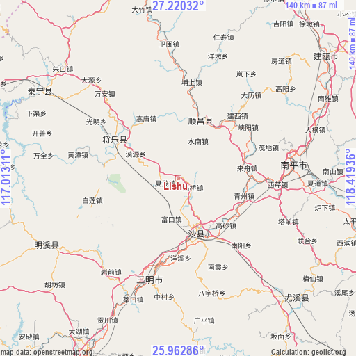
Lishu GPS coordinates[2]
26° 35' 35.952" North, 117° 42' 58.428" East
| Map corner | latitude | longitude |
|---|---|---|
| Upper-left | 27.22032°, | 117.01311° |
| Center: | 26.59332°, | 117.71623° |
| Lower-right: | 25.96286°, | 118.41936° |
| Map W x H: | 139.8×139.8 km | = 86.9×86.9mi |
| max Lat: | 53.31946° ⇑80.1% North |
| Lishu: | 26.59332° |
| min Lat: | ⇓19.9% South 18.22056° |
| min Long | Lishu | max Long |
| 75.07348° | 117.71623° | 134.28917° |
| W 69.5%⇐ | ⇒30.5% E |
Elevation
Elevation of Lishu is 223 m = 732 ft, and this is 261.8 m = 859 ft below average elevation for this country.
| Max E: |
5622 m = 18445 ft | 43.3% |
| Avg. | 484.8 m = 1591 ft | |
| Lishu | 223 m = 732 ft | |
Min E: |
-3 m = -10 ft | 56.7% |
See also: China elevation on elevation.city.
Geographical zone
Lishu is located in North temperate zone (between Tropic of Cancer and the Arctic Circle). Distance of this Northern Tropic circle is 351 km =218.1 mi to South.| Distance of | km | miles | from Lishu |
|---|---|---|---|
| North Pole | 7050.2 | 4380.8 | to North |
| Arctic Circle | 4444.3 | 2761.6 | to North |
| Tropic Cancer | 351 | 218.1 | to South |
| Equator | 2956.9 | 1837.3 | to South |


Nearby cities:
15 places around Lishu: (largest is in red/bold)
• Fukou
16.3 km =10.1 mi,  189°
189°
• Gaoqiao
6.9 km =4.3 mi,  122°
122°
• Gaosha
26.3 km =16.3 mi,  134°
134°
• Gaotang
26.6 km =16.5 mi,  331°
331°
• Guyong
29 km =18 mi,  301°
301°
• Laizhou
27 km =16.8 mi,  81°
81°
• Langkou
26 km =16.2 mi,  151°
151°
• Moyuan
19.1 km =11.9 mi, 300°
• Qingzhou
26.8 km =16.7 mi,  104°
104°
• Qiujiang
23.1 km =14.4 mi,  165°
165°
• Shuinan
16.6 km =10.3 mi,  28°
28°
• Wangtai
25.7 km =16 mi, 78°
• Xiamao
5.4 km =3.4 mi,  249°
249°
• Yuankeng
18.7 km =11.6 mi,  358°
358°
• Zhengfang
13.4 km =8.3 mi, 356°
Sources, notices
• [Note1] Compared only with cities in China existing in our database
• [Src1] Map data: © OpenStreetMap contributors (CC-BY-SA)
• [Src2] Other city data from geonames.org with taken over terms of usage.
• [Src3] Geographical zone / Annual Mean Temperature by Robert A. Rohde @ Wikipedia
