Tangfang geodata
Tangfang (Jiangxi) is a seat of a fourth-order administrative division; located in China in Asia/Shanghai (GMT+8) time zone. In our database, there are 1268 cities with bigger population. Compared to other cities in China, 80% of cities are located further ↑North; 63% of cities are located further ←West and 58.6% of cities have lower elevation than Tangfang. Note1


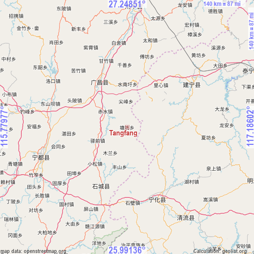
Tangfang GPS coordinates[2]
26° 37' 17.976" North, 116° 28' 58.404" East
| Map corner | latitude | longitude |
|---|---|---|
| Upper-left | 27.24851°, | 115.77977° |
| Center: | 26.62166°, | 116.48289° |
| Lower-right: | 25.99136°, | 117.18602° |
| Map W x H: | 139.8×139.8 km | = 86.9×86.9mi |
| max Lat: | 53.31946° ⇑80% North |
| Tangfang: | 26.62166° |
| min Lat: | ⇓20% South 18.22056° |
| min Long | Tangfang | max Long |
| 75.07348° | 116.48289° | 134.28917° |
| W 63%⇐ | ⇒37% E |
Elevation
Elevation of Tangfang is 242 m = 794 ft, and this is 242.8 m = 797 ft below average elevation for this country.
| Max E: |
5622 m = 18445 ft | 41.4% |
| Avg. | 484.8 m = 1591 ft | |
| Tangfang | 242 m = 794 ft | |
Min E: |
-3 m = -10 ft | 58.6% |
See also: China elevation on elevation.city.
Geographical zone
Tangfang is located in North temperate zone (between Tropic of Cancer and the Arctic Circle). Distance of this Northern Tropic circle is 354.1 km =220 mi to South.| Distance of | km | miles | from Tangfang |
|---|---|---|---|
| North Pole | 7047 | 4378.8 | to North |
| Arctic Circle | 4441.1 | 2759.6 | to North |
| Tropic Cancer | 354.1 | 220 | to South |
| Equator | 2960.1 | 1839.3 | to South |


Nearby cities:
15 places around Tangfang: (largest is in red/bold)
• Anyuan
19.8 km =12.3 mi,  104°
104°
• Changqiao
24.3 km =15.1 mi,  342°
342°
• Chishui
14.8 km =9.2 mi,  306°
306°
• Dushang
28 km =17.4 mi,  74°
74°
• Fengshan
22.1 km =13.7 mi,  191°
191°
• Gaotian
16.8 km =10.4 mi,  184°
184°
• Helong
25.9 km =16.1 mi,  138°
138°
• Huangbu
21.6 km =13.4 mi,  51°
51°
• Jianfeng
14.4 km =8.9 mi,  357°
357°
• Kefang
14.8 km =9.2 mi,  44°
44°
• Mulan
16.7 km =10.4 mi,  213°
213°
• Shuinanxu
23.8 km =14.8 mi,  0°
0°
• Xiaosong
26.6 km =16.5 mi,  221°
221°
• Yangxi
9 km =5.6 mi,  270°
270°
• Yiqian
17.7 km =11 mi,  245°
245°
Sources, notices
• [Note1] Compared only with cities in China existing in our database
• [Src1] Map data: © OpenStreetMap contributors (CC-BY-SA)
• [Src2] Other city data from geonames.org with taken over terms of usage.
• [Src3] Geographical zone / Annual Mean Temperature by Robert A. Rohde @ Wikipedia
