Nanqiao geodata
Nanqiao (Jiangxi) is a seat of a fourth-order administrative division; located in China in Asia/Shanghai (GMT+8) time zone. In our database, there are 1268 cities with bigger population. Compared to other cities in China, 87.2% of cities are located further ↑North; 58.2% of cities are located further ←West and 60.9% of cities have lower elevation than Nanqiao. Note1


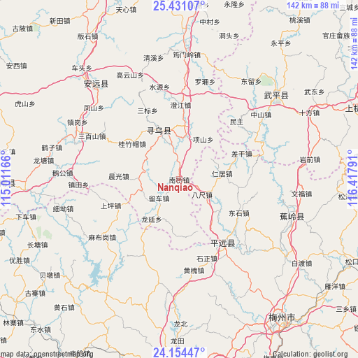
Nanqiao GPS coordinates[2]
24° 47' 39.876" North, 115° 42' 53.208" East
| Map corner | latitude | longitude |
|---|---|---|
| Upper-left | 25.43107°, | 115.01166° |
| Center: | 24.79441°, | 115.71478° |
| Lower-right: | 24.15447°, | 116.41791° |
| Map W x H: | 141.9×141.9 km | = 88.2×88.2mi |
| max Lat: | 53.31946° ⇑87.2% North |
| Nanqiao: | 24.79441° |
| min Lat: | ⇓12.8% South 18.22056° |
| min Long | Nanqiao | max Long |
| 75.07348° | 115.71478° | 134.28917° |
| W 58.2%⇐ | ⇒41.8% E |
Elevation
Elevation of Nanqiao is 269 m = 883 ft, and this is 215.8 m = 708 ft below average elevation for this country.
| Max E: |
5622 m = 18445 ft | 39.1% |
| Avg. | 484.8 m = 1591 ft | |
| Nanqiao | 269 m = 883 ft | |
Min E: |
-3 m = -10 ft | 60.9% |
See also: China elevation on elevation.city.
Geographical zone
Nanqiao is located in North temperate zone (between Tropic of Cancer and the Arctic Circle). Distance of this Northern Tropic circle is 151 km =93.8 mi to South.| Distance of | km | miles | from Nanqiao |
|---|---|---|---|
| North Pole | 7250.2 | 4505.1 | to North |
| Arctic Circle | 4644.3 | 2885.8 | to North |
| Tropic Cancer | 151 | 93.8 | to South |
| Equator | 2756.9 | 1713.1 | to South |


Nearby cities:
15 places around Nanqiao: (largest is in red/bold)
• Bachi
10.8 km =6.7 mi,  123°
123°
• Changning
19.4 km =12.1 mi,  337°
337°
• Changpu
20.2 km =12.6 mi,  253°
253°
• Chenguang
24 km =14.9 mi,  273°
273°
• Danxi
21.5 km =13.4 mi,  163°
163°
• Guizhumao
23.5 km =14.6 mi,  307°
307°
• Hetou
20.4 km =12.7 mi,  128°
128°
• Huangshe
12.4 km =7.7 mi,  83°
83°
• Jitan
17.4 km =10.8 mi,  9°
9°
• Liuche
10.9 km =6.8 mi,  227°
227°
• Longting
19 km =11.8 mi,  215°
215°
• Renju
17.2 km =10.7 mi, 81°
• Wenfeng
20.6 km =12.8 mi, 336°
• Xiangshan
18.7 km =11.6 mi,  30°
30°
• Zhongxing
18.2 km =11.3 mi,  143°
143°
Sources, notices
• [Note1] Compared only with cities in China existing in our database
• [Src1] Map data: © OpenStreetMap contributors (CC-BY-SA)
• [Src2] Other city data from geonames.org with taken over terms of usage.
• [Src3] Geographical zone / Annual Mean Temperature by Robert A. Rohde @ Wikipedia
