Renju geodata
Renju (Guangdong) is a seat of a fourth-order administrative division; located in China in Asia/Shanghai (GMT+8) time zone. In our database, there are 1268 cities with bigger population. Compared to other cities in China, 87.2% of cities are located further ↑North; 59.4% of cities are located further ←West and 59.4% of cities have lower elevation than Renju. Note1


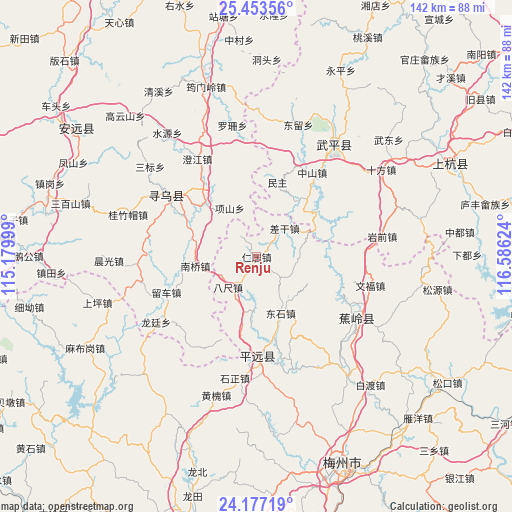
Renju GPS coordinates[2]
24° 49' 1.272" North, 115° 52' 59.196" East
| Map corner | latitude | longitude |
|---|---|---|
| Upper-left | 25.45356°, | 115.17999° |
| Center: | 24.81702°, | 115.88311° |
| Lower-right: | 24.17719°, | 116.58624° |
| Map W x H: | 141.9×141.9 km | = 88.2×88.2mi |
| max Lat: | 53.31946° ⇑87.2% North |
| Renju: | 24.81702° |
| min Lat: | ⇓12.8% South 18.22056° |
| min Long | Renju | max Long |
| 75.07348° | 115.88311° | 134.28917° |
| W 59.4%⇐ | ⇒40.6% E |
Elevation
Elevation of Renju is 252 m = 827 ft, and this is 232.8 m = 764 ft below average elevation for this country.
| Max E: |
5622 m = 18445 ft | 40.6% |
| Avg. | 484.8 m = 1591 ft | |
| Renju | 252 m = 827 ft | |
Min E: |
-3 m = -10 ft | 59.4% |
See also: China elevation on elevation.city.
Geographical zone
Renju is located in North temperate zone (between Tropic of Cancer and the Arctic Circle). Distance of this Northern Tropic circle is 153.5 km =95.4 mi to South.| Distance of | km | miles | from Renju |
|---|---|---|---|
| North Pole | 7247.7 | 4503.5 | to North |
| Arctic Circle | 4641.8 | 2884.3 | to North |
| Tropic Cancer | 153.5 | 95.4 | to South |
| Equator | 2759.4 | 1714.6 | to South |


Nearby cities:
15 places around Renju: (largest is in red/bold)
• Bachi
11.6 km =7.2 mi,  223°
223°
• Batou
23.3 km =14.5 mi,  167°
167°
• Chagan
10.9 km =6.8 mi,  44°
44°
• Dongshi
16.7 km =10.4 mi,  156°
156°
• Hetou
15.2 km =9.4 mi,  183°
183°
• Huangshe
4.8 km =3 mi,  256°
256°
• Jitan
20.3 km =12.6 mi,  316°
316°
• Maoping
21.4 km =13.3 mi,  151°
151°
• Minzhu
21.4 km =13.3 mi,  15°
15°
• Nanqiao
17.2 km =10.7 mi, 261°
• Shangju
10.8 km =6.7 mi,  107°
107°
• Sishui
16.1 km =10 mi,  116°
116°
• Xiaba
17.1 km =10.6 mi,  65°
65°
• Xiangshan
15.5 km =9.6 mi,  331°
331°
• Zhongxing
18.2 km =11.3 mi,  199°
199°
Sources, notices
• [Note1] Compared only with cities in China existing in our database
• [Src1] Map data: © OpenStreetMap contributors (CC-BY-SA)
• [Src2] Other city data from geonames.org with taken over terms of usage.
• [Src3] Geographical zone / Annual Mean Temperature by Robert A. Rohde @ Wikipedia
