Longting geodata
Longting (Jiangxi) is a seat of a fourth-order administrative division; located in China in Asia/Shanghai (GMT+8) time zone. In our database, there are 1268 cities with bigger population. Compared to other cities in China, 87.9% of cities are located further ↑North; 57.6% of cities are located further ←West and 59.6% of cities have lower elevation than Longting. Note1


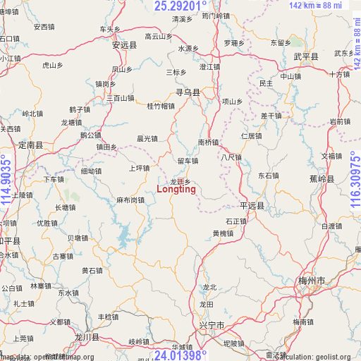
Longting GPS coordinates[2]
24° 39' 16.668" North, 115° 36' 23.832" East
| Map corner | latitude | longitude |
|---|---|---|
| Upper-left | 25.29201°, | 114.9035° |
| Center: | 24.65463°, | 115.60662° |
| Lower-right: | 24.01398°, | 116.30975° |
| Map W x H: | 142.1×142.1 km | = 88.3×88.3mi |
| max Lat: | 53.31946° ⇑87.9% North |
| Longting: | 24.65463° |
| min Lat: | ⇓12.1% South 18.22056° |
| min Long | Longting | max Long |
| 75.07348° | 115.60662° | 134.28917° |
| W 57.6%⇐ | ⇒42.4% E |
Elevation
Elevation of Longting is 255 m = 837 ft, and this is 229.8 m = 754 ft below average elevation for this country.
| Max E: |
5622 m = 18445 ft | 40.4% |
| Avg. | 484.8 m = 1591 ft | |
| Longting | 255 m = 837 ft | |
Min E: |
-3 m = -10 ft | 59.6% |
See also: China elevation on elevation.city.
Geographical zone
Longting is located in North temperate zone (between Tropic of Cancer and the Arctic Circle). Distance of this Northern Tropic circle is 135.4 km =84.1 mi to South.| Distance of | km | miles | from Longting |
|---|---|---|---|
| North Pole | 7265.7 | 4514.7 | to North |
| Arctic Circle | 4659.8 | 2895.5 | to North |
| Tropic Cancer | 135.4 | 84.1 | to South |
| Equator | 2741.3 | 1703.4 | to South |


Nearby cities:
15 places around Longting: (largest is in red/bold)
• Bachi
22.2 km =13.8 mi,  64°
64°
• Changpu
12.9 km =8 mi,  318°
318°
• Chenguang
21.4 km =13.3 mi, 322°
• Danxi
17.8 km =11.1 mi,  106°
106°
• Hetou
27.1 km =16.8 mi,  83°
83°
• Huanghuai
26.8 km =16.7 mi,  140°
140°
• Liuche
8.7 km =5.4 mi,  19°
19°
• Luofu
14.4 km =8.9 mi,  191°
191°
• Luogang
25.5 km =15.8 mi,  174°
174°
• Mabugang
20.7 km =12.9 mi,  249°
249°
• Nanqiao
19 km =11.8 mi,  35°
35°
• Shangping
17.1 km =10.6 mi,  288°
288°
• Xintian
23.7 km =14.7 mi,  201°
201°
• Yanzhen
24.2 km =15 mi,  220°
220°
• Zhongxing
21.8 km =13.5 mi,  87°
87°
Sources, notices
• [Note1] Compared only with cities in China existing in our database
• [Src1] Map data: © OpenStreetMap contributors (CC-BY-SA)
• [Src2] Other city data from geonames.org with taken over terms of usage.
• [Src3] Geographical zone / Annual Mean Temperature by Robert A. Rohde @ Wikipedia
