Jitan geodata
Jitan (Jiangxi) is a seat of a fourth-order administrative division; located in China in Asia/Shanghai (GMT+8) time zone. In our database, there are 1268 cities with bigger population. Compared to other cities in China, 86.6% of cities are located further ↑North; 58.4% of cities are located further ←West and 61.5% of cities have lower elevation than Jitan. Note1


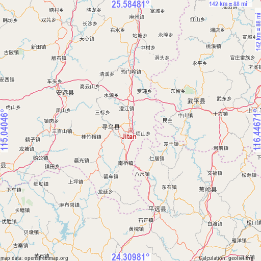
Jitan GPS coordinates[2]
24° 56' 56.256" North, 115° 44' 36.888" East
| Map corner | latitude | longitude |
|---|---|---|
| Upper-left | 25.58481°, | 115.04046° |
| Center: | 24.94896°, | 115.74358° |
| Lower-right: | 24.30981°, | 116.44671° |
| Map W x H: | 141.8×141.8 km | = 88.1×88.1mi |
| max Lat: | 53.31946° ⇑86.6% North |
| Jitan: | 24.94896° |
| min Lat: | ⇓13.4% South 18.22056° |
| min Long | Jitan | max Long |
| 75.07348° | 115.74358° | 134.28917° |
| W 58.4%⇐ | ⇒41.6% E |
Elevation
Elevation of Jitan is 277 m = 909 ft, and this is 207.8 m = 682 ft below average elevation for this country.
| Max E: |
5622 m = 18445 ft | 38.5% |
| Avg. | 484.8 m = 1591 ft | |
| Jitan | 277 m = 909 ft | |
Min E: |
-3 m = -10 ft | 61.5% |
See also: China elevation on elevation.city.
Geographical zone
Jitan is located in North temperate zone (between Tropic of Cancer and the Arctic Circle). Distance of this Northern Tropic circle is 168.1 km =104.5 mi to South.| Distance of | km | miles | from Jitan |
|---|---|---|---|
| North Pole | 7233 | 4494.4 | to North |
| Arctic Circle | 4627.1 | 2875.1 | to North |
| Tropic Cancer | 168.1 | 104.5 | to South |
| Equator | 2774.1 | 1723.7 | to South |


Nearby cities:
15 places around Jitan: (largest is in red/bold)
• Bachi
23.9 km =14.9 mi,  165°
165°
• Chagan
22.8 km =14.2 mi,  107°
107°
• Changning
10.2 km =6.3 mi,  274°
274°
• Chengjiang
12.7 km =7.9 mi,  349°
349°
• Guizhumao
21.7 km =13.5 mi,  262°
262°
• Huangshe
18.4 km =11.4 mi,  149°
149°
• Liuche
26.8 km =16.7 mi,  204°
204°
• Luoshan
23 km =14.3 mi,  18°
18°
• Minzhu
20.7 km =12.9 mi,  73°
73°
• Nanqiao
17.4 km =10.8 mi,  189°
189°
• Renju
20.3 km =12.6 mi,  136°
136°
• Sanbiao
18.6 km =11.6 mi,  303°
303°
• Shuiyuan
22.4 km =13.9 mi,  331°
331°
• Wenfeng
11.2 km =7 mi,  278°
278°
• Xiangshan
6.7 km =4.2 mi,  99°
99°
Sources, notices
• [Note1] Compared only with cities in China existing in our database
• [Src1] Map data: © OpenStreetMap contributors (CC-BY-SA)
• [Src2] Other city data from geonames.org with taken over terms of usage.
• [Src3] Geographical zone / Annual Mean Temperature by Robert A. Rohde @ Wikipedia
