Hefeng geodata
Hefeng (Jiangxi) is a seat of a fourth-order administrative division; located in China in Asia/Shanghai (GMT+8) time zone. In our database, there are 1268 cities with bigger population. Compared to other cities in China, 83.2% of cities are located further ↑North; 56.9% of cities are located further ←West and 52.5% of cities have lower elevation than Hefeng. Note1


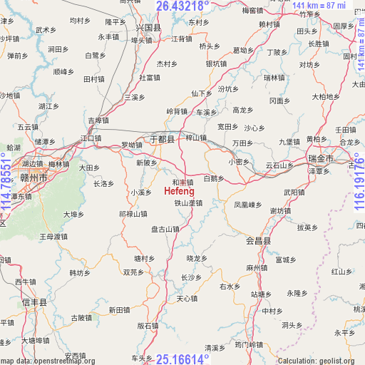
Hefeng GPS coordinates[2]
25° 48' 3.06" North, 115° 29' 19.068" East
| Map corner | latitude | longitude |
|---|---|---|
| Upper-left | 26.43218°, | 114.78551° |
| Center: | 25.80085°, | 115.48863° |
| Lower-right: | 25.16614°, | 116.19176° |
| Map W x H: | 140.8×140.8 km | = 87.5×87.5mi |
| max Lat: | 53.31946° ⇑83.2% North |
| Hefeng: | 25.80085° |
| min Lat: | ⇓16.8% South 18.22056° |
| min Long | Hefeng | max Long |
| 75.07348° | 115.48863° | 134.28917° |
| W 56.9%⇐ | ⇒43.1% E |
Elevation
Elevation of Hefeng is 185 m = 607 ft, and this is 299.8 m = 984 ft below average elevation for this country.
| Max E: |
5622 m = 18445 ft | 47.5% |
| Avg. | 484.8 m = 1591 ft | |
| Hefeng | 185 m = 607 ft | |
Min E: |
-3 m = -10 ft | 52.5% |
See also: China elevation on elevation.city.
Geographical zone
Hefeng is located in North temperate zone (between Tropic of Cancer and the Arctic Circle). Distance of this Northern Tropic circle is 262.9 km =163.4 mi to South.| Distance of | km | miles | from Hefeng |
|---|---|---|---|
| North Pole | 7138.3 | 4435.5 | to North |
| Arctic Circle | 4532.4 | 2816.3 | to North |
| Tropic Cancer | 262.9 | 163.4 | to South |
| Equator | 2868.8 | 1782.6 | to South |


Nearby cities:
15 places around Hefeng: (largest is in red/bold)
• Bai’e
12.3 km =7.6 mi,  80°
80°
• Gongjiang
19.1 km =11.9 mi,  335°
335°
• Huanglin
18.6 km =11.6 mi,  45°
45°
• Jingshi
14.7 km =9.1 mi,  176°
176°
• Licun
10.9 km =6.8 mi,  298°
298°
• Luo’ao
24.6 km =15.3 mi,  307°
307°
• Pangushan
18.8 km =11.7 mi,  200°
200°
• Qilushan
22.3 km =13.9 mi,  238°
238°
• Tieshanlong
7.8 km =4.8 mi,  163°
163°
• Xiaomi
23.4 km =14.5 mi,  68°
68°
• Xiaoxi
16.2 km =10.1 mi,  257°
257°
• Xinbei
16.3 km =10.1 mi, 299°
• Zhuangbu
15.5 km =9.6 mi,  137°
137°
• Zhuangkou
18.1 km =11.2 mi,  112°
112°
• Zishan
18.5 km =11.5 mi,  16°
16°
Sources, notices
• [Note1] Compared only with cities in China existing in our database
• [Src1] Map data: © OpenStreetMap contributors (CC-BY-SA)
• [Src2] Other city data from geonames.org with taken over terms of usage.
• [Src3] Geographical zone / Annual Mean Temperature by Robert A. Rohde @ Wikipedia
