Jinshanzui geodata
Jinshanzui (Jiangxi) is a seat of a fourth-order administrative division; located in China in Asia/Shanghai (GMT+8) time zone. In our database, there are 1268 cities with bigger population. Compared to other cities in China, 67.6% of cities are located further ↑North; 63.4% of cities are located further ←West and 83.9% of cities have higher elevation than Jinshanzui. Note1


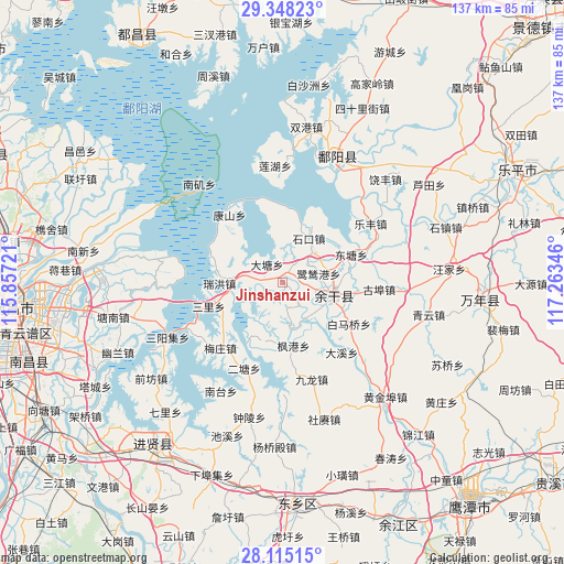
Jinshanzui GPS coordinates[2]
28° 44' 0.636" North, 116° 33' 37.188" East
| Map corner | latitude | longitude |
|---|---|---|
| Upper-left | 29.34823°, | 115.85721° |
| Center: | 28.73351°, | 116.56033° |
| Lower-right: | 28.11515°, | 117.26346° |
| Map W x H: | 137.1×137.1 km | = 85.2×85.2mi |
| max Lat: | 53.31946° ⇑67.6% North |
| Jinshanzui: | 28.73351° |
| min Lat: | ⇓32.4% South 18.22056° |
| min Long | Jinshanzui | max Long |
| 75.07348° | 116.56033° | 134.28917° |
| W 63.4%⇐ | ⇒36.6% E |
Elevation
Elevation of Jinshanzui is 18 m = 59 ft, and this is 466.8 m = 1531 ft below average elevation for this country.
| Max E: |
5622 m = 18445 ft | 83.9% |
| Avg. | 484.8 m = 1591 ft | |
| Jinshanzui | 18 m = 59 ft | |
Min E: |
-3 m = -10 ft | 16.1% |
See also: China elevation on elevation.city.
Geographical zone
Jinshanzui is located in North temperate zone (between Tropic of Cancer and the Arctic Circle). Distance of this Northern Tropic circle is 588.9 km =365.9 mi to South.| Distance of | km | miles | from Jinshanzui |
|---|---|---|---|
| North Pole | 6812.2 | 4232.9 | to North |
| Arctic Circle | 4206.3 | 2613.7 | to North |
| Tropic Cancer | 588.9 | 365.9 | to South |
| Equator | 3194.9 | 1985.2 | to South |


Nearby cities:
15 places around Jinshanzui: (largest is in red/bold)
• Baimaqiao
20.2 km =12.6 mi,  120°
120°
• Datang
6.6 km =4.1 mi,  321°
321°
• Dongyuan
11.6 km =7.2 mi,  290°
290°
• Fenggang
15.7 km =9.8 mi,  170°
170°
• Heshan
15.1 km =9.4 mi,  182°
182°
• Hongjiazui
10.2 km =6.3 mi,  111°
111°
• Hualingang
13.3 km =8.3 mi,  103°
103°
• Jiangbu
11.5 km =7.1 mi, 170°
• Lusigang
9 km =5.6 mi,  75°
75°
• Meixi
16.7 km =10.4 mi,  284°
284°
• Ruihong
15.2 km =9.4 mi,  268°
268°
• Sanli
18.7 km =11.6 mi,  251°
251°
• Santang
0.7 km =0.4 mi,  74°
74°
• Shikou
12.4 km =7.7 mi,  30°
30°
• Yugan
12.8 km =8 mi, 109°
Sources, notices
• [Note1] Compared only with cities in China existing in our database
• [Src1] Map data: © OpenStreetMap contributors (CC-BY-SA)
• [Src2] Other city data from geonames.org with taken over terms of usage.
• [Src3] Geographical zone / Annual Mean Temperature by Robert A. Rohde @ Wikipedia
