Songhu geodata
Songhu (Jiangxi) is a seat of a fourth-order administrative division; located in China in Asia/Shanghai (GMT+8) time zone. In our database, there are 1268 cities with bigger population. Compared to other cities in China, 74.6% of cities are located further ↑North; 62.9% of cities are located further ←West and 71.9% of cities have higher elevation than Songhu. Note1


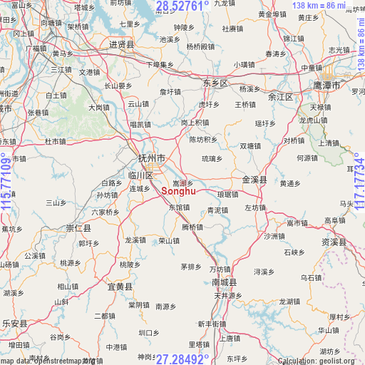
Songhu GPS coordinates[2]
27° 54' 28.98" North, 116° 28' 27.156" East
| Map corner | latitude | longitude |
|---|---|---|
| Upper-left | 28.52761°, | 115.77109° |
| Center: | 27.90805°, | 116.47421° |
| Lower-right: | 27.28492°, | 117.17734° |
| Map W x H: | 138.2×138.2 km | = 85.9×85.9mi |
| max Lat: | 53.31946° ⇑74.6% North |
| Songhu: | 27.90805° |
| min Lat: | ⇓25.4% South 18.22056° |
| min Long | Songhu | max Long |
| 75.07348° | 116.47421° | 134.28917° |
| W 62.9%⇐ | ⇒37.1% E |
Elevation
Elevation of Songhu is 45 m = 148 ft, and this is 439.8 m = 1443 ft below average elevation for this country.
| Max E: |
5622 m = 18445 ft | 71.9% |
| Avg. | 484.8 m = 1591 ft | |
| Songhu | 45 m = 148 ft | |
Min E: |
-3 m = -10 ft | 28.1% |
See also: China elevation on elevation.city.
Geographical zone
Songhu is located in North temperate zone (between Tropic of Cancer and the Arctic Circle). Distance of this Northern Tropic circle is 497.2 km =308.9 mi to South.| Distance of | km | miles | from Songhu |
|---|---|---|---|
| North Pole | 6904 | 4289.9 | to North |
| Arctic Circle | 4298.1 | 2670.7 | to North |
| Tropic Cancer | 497.2 | 308.9 | to South |
| Equator | 3103.1 | 1928.2 | to South |


Nearby cities:
15 places around Songhu: (largest is in red/bold)
• Chonggang
9.8 km =6.1 mi,  272°
272°
• Dengfang
11.9 km =7.4 mi,  155°
155°
• Dongguan
9.1 km =5.7 mi,  188°
188°
• Hebu
15.3 km =9.5 mi,  209°
209°
• Huwan
7.4 km =4.6 mi,  78°
78°
• Jinggonglu
15.3 km =9.5 mi,  309°
309°
• Liancheng
16.5 km =10.3 mi,  264°
264°
• Qiaodong
15 km =9.3 mi, 312°
• Qiligang
12.3 km =7.6 mi,  336°
336°
• Qingyun
14.4 km =8.9 mi, 306°
• Shangdundu
18.1 km =11.2 mi,  280°
280°
• Taiyang
17.1 km =10.6 mi,  1°
1°
• Tengqiao
16.7 km =10.4 mi,  167°
167°
• Xidajie
15.5 km =9.6 mi, 309°
• Zhongling
10.5 km =6.5 mi,  300°
300°
Sources, notices
• [Note1] Compared only with cities in China existing in our database
• [Src1] Map data: © OpenStreetMap contributors (CC-BY-SA)
• [Src2] Other city data from geonames.org with taken over terms of usage.
• [Src3] Geographical zone / Annual Mean Temperature by Robert A. Rohde @ Wikipedia
