Tacheng geodata
Tacheng (Jiangxi) is a seat of a fourth-order administrative division; located in China in Asia/Shanghai (GMT+8) time zone. In our database, there are 1268 cities with bigger population. Compared to other cities in China, 69.7% of cities are located further ↑North; 60.6% of cities are located further ←West and 81.6% of cities have higher elevation than Tacheng. Note1


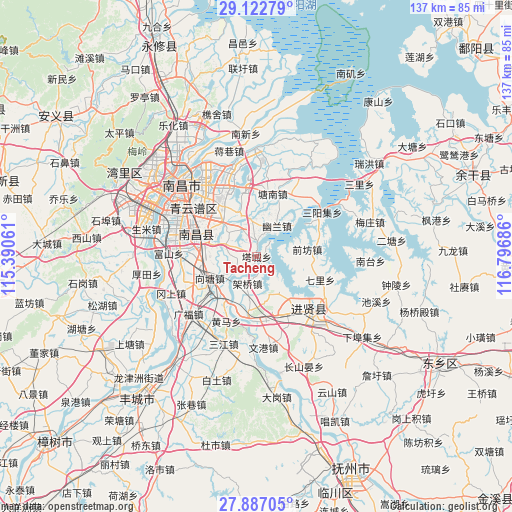
Tacheng GPS coordinates[2]
28° 30' 24.228" North, 116° 5' 37.428" East
| Map corner | latitude | longitude |
|---|---|---|
| Upper-left | 29.12279°, | 115.39061° |
| Center: | 28.50673°, | 116.09373° |
| Lower-right: | 27.88705°, | 116.79686° |
| Map W x H: | 137.4×137.4 km | = 85.4×85.4mi |
| max Lat: | 53.31946° ⇑69.7% North |
| Tacheng: | 28.50673° |
| min Lat: | ⇓30.3% South 18.22056° |
| min Long | Tacheng | max Long |
| 75.07348° | 116.09373° | 134.28917° |
| W 60.6%⇐ | ⇒39.4% E |
Elevation
Elevation of Tacheng is 23 m = 75 ft, and this is 461.8 m = 1515 ft below average elevation for this country.
| Max E: |
5622 m = 18445 ft | 81.6% |
| Avg. | 484.8 m = 1591 ft | |
| Tacheng | 23 m = 75 ft | |
Min E: |
-3 m = -10 ft | 18.4% |
See also: China elevation on elevation.city.
Geographical zone
Tacheng is located in North temperate zone (between Tropic of Cancer and the Arctic Circle). Distance of this Northern Tropic circle is 563.7 km =350.3 mi to South.| Distance of | km | miles | from Tacheng |
|---|---|---|---|
| North Pole | 6837.4 | 4248.6 | to North |
| Arctic Circle | 4231.5 | 2629.3 | to North |
| Tropic Cancer | 563.7 | 350.3 | to South |
| Equator | 3169.7 | 1969.6 | to South |


Nearby cities:
15 places around Tacheng: (largest is in red/bold)
• Fushan
23.5 km =14.6 mi,  272°
272°
• Gangshang
24.6 km =15.3 mi,  246°
246°
• Huangma
19 km =11.8 mi,  204°
204°
• Jingkou
17.4 km =10.8 mi,  22°
22°
• Luoxi
11.6 km =7.2 mi,  151°
151°
• Maqiu
18.3 km =11.4 mi,  355°
355°
• Qianfang
13.8 km =8.6 mi,  82°
82°
• Qili
18.3 km =11.4 mi,  110°
110°
• Quanling
14.5 km =9 mi,  188°
188°
• Tangnanzhen
17.4 km =10.8 mi,  13°
13°
• Wengang
24.5 km =15.2 mi,  176°
176°
• Wuyang
8.2 km =5.1 mi,  279°
279°
• Xiangtang
15.6 km =9.7 mi,  235°
235°
• Youlan
9.8 km =6.1 mi,  33°
33°
• Zhaobu
17.9 km =11.1 mi,  66°
66°
Sources, notices
• [Note1] Compared only with cities in China existing in our database
• [Src1] Map data: © OpenStreetMap contributors (CC-BY-SA)
• [Src2] Other city data from geonames.org with taken over terms of usage.
• [Src3] Geographical zone / Annual Mean Temperature by Robert A. Rohde @ Wikipedia
