Tangnanzhen geodata
Tangnanzhen (Jiangxi) is a seat of a fourth-order administrative division; located in China in Asia/Shanghai (GMT+8) time zone. In our database, there are 1268 cities with bigger population. Compared to other cities in China, 68.4% of cities are located further ↑North; 60.8% of cities are located further ←West and 82.9% of cities have higher elevation than Tangnanzhen. Note1


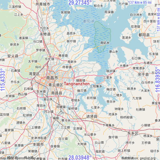
Tangnanzhen GPS coordinates[2]
28° 39' 29.808" North, 116° 8' 11.112" East
| Map corner | latitude | longitude |
|---|---|---|
| Upper-left | 29.27345°, | 115.4333° |
| Center: | 28.65828°, | 116.13642° |
| Lower-right: | 28.03948°, | 116.83955° |
| Map W x H: | 137.2×137.2 km | = 85.3×85.3mi |
| max Lat: | 53.31946° ⇑68.4% North |
| Tangnanzhen: | 28.65828° |
| min Lat: | ⇓31.6% South 18.22056° |
| min Long | Tangnanzhen | max Long |
| 75.07348° | 116.13642° | 134.28917° |
| W 60.8%⇐ | ⇒39.2% E |
Elevation
Elevation of Tangnanzhen is 20 m = 66 ft, and this is 464.8 m = 1525 ft below average elevation for this country.
| Max E: |
5622 m = 18445 ft | 82.9% |
| Avg. | 484.8 m = 1591 ft | |
| Tangnanzhen | 20 m = 66 ft | |
Min E: |
-3 m = -10 ft | 17.1% |
See also: China elevation on elevation.city.
Geographical zone
Tangnanzhen is located in North temperate zone (between Tropic of Cancer and the Arctic Circle). Distance of this Northern Tropic circle is 580.6 km =360.8 mi to South.| Distance of | km | miles | from Tangnanzhen |
|---|---|---|---|
| North Pole | 6820.6 | 4238.1 | to North |
| Arctic Circle | 4214.7 | 2618.9 | to North |
| Tropic Cancer | 580.6 | 360.8 | to South |
| Equator | 3186.5 | 1980 | to South |


Nearby cities:
15 places around Tangnanzhen: (largest is in red/bold)
• Jiangxiangzhen
16.3 km =10.1 mi,  314°
314°
• Jingkou
2.5 km =1.6 mi,  107°
107°
• Luoxi
27.1 km =16.8 mi,  177°
177°
• Maqiu
5.8 km =3.6 mi,  284°
284°
• Nanxinxiang
17.4 km =10.8 mi,  335°
335°
• Qianfang
17.7 km =11 mi,  147°
147°
• Qiaoshe
26 km =16.2 mi,  325°
325°
• Qili
26.7 km =16.6 mi, 151°
• Sanli
23.7 km =14.7 mi,  83°
83°
• Tacheng
17.4 km =10.8 mi,  193°
193°
• Taohua
25.7 km =16 mi,  268°
268°
• Wuyang
19.8 km =12.3 mi,  218°
218°
• Yangzizhou
23.6 km =14.7 mi,  287°
287°
• Youlan
8.8 km =5.5 mi,  171°
171°
• Zhaobu
15.7 km =9.8 mi,  128°
128°
Sources, notices
• [Note1] Compared only with cities in China existing in our database
• [Src1] Map data: © OpenStreetMap contributors (CC-BY-SA)
• [Src2] Other city data from geonames.org with taken over terms of usage.
• [Src3] Geographical zone / Annual Mean Temperature by Robert A. Rohde @ Wikipedia
