Guantouzui geodata
Guantouzui (Hunan) is a seat of a fourth-order administrative division; located in China in Asia/Shanghai (GMT+8) time zone. In our database, there are 1268 cities with bigger population. Compared to other cities in China, 64.8% of cities are located further ↑North; 62.7% of cities are located further →East and 76.2% of cities have higher elevation than Guantouzui. Note1


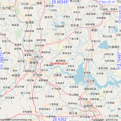
Guantouzui GPS coordinates[2]
29° 3' 9.648" North, 112° 0' 6.624" East
| Map corner | latitude | longitude |
|---|---|---|
| Upper-left | 29.66549°, | 111.29872° |
| Center: | 29.05268°, | 112.00184° |
| Lower-right: | 28.4362°, | 112.70497° |
| Map W x H: | 136.7×136.7 km | = 84.9×84.9mi |
| max Lat: | 53.31946° ⇑64.8% North |
| Guantouzui: | 29.05268° |
| min Lat: | ⇓35.2% South 18.22056° |
| min Long | Guantouzui | max Long |
| 75.07348° | 112.00184° | 134.28917° |
| W 37.3%⇐ | ⇒62.7% E |
Elevation
Elevation of Guantouzui is 34 m = 112 ft, and this is 450.8 m = 1479 ft below average elevation for this country.
| Max E: |
5622 m = 18445 ft | 76.2% |
| Avg. | 484.8 m = 1591 ft | |
| Guantouzui | 34 m = 112 ft | |
Min E: |
-3 m = -10 ft | 23.8% |
See also: China elevation on elevation.city.
Geographical zone
Guantouzui is located in North temperate zone (between Tropic of Cancer and the Arctic Circle). Distance of this Northern Tropic circle is 624.4 km =388 mi to South.| Distance of | km | miles | from Guantouzui |
|---|---|---|---|
| North Pole | 6776.7 | 4210.8 | to North |
| Arctic Circle | 4170.8 | 2591.6 | to North |
| Tropic Cancer | 624.4 | 388 | to South |
| Equator | 3230.4 | 2007.3 | to South |


Nearby cities:
15 places around Guantouzui: (largest is in red/bold)
• Baiheshan
19.9 km =12.4 mi,  289°
289°
• Canggang
19.4 km =12.1 mi,  215°
215°
• Hangongdu
9 km =5.6 mi,  296°
296°
• Hanshou
16.9 km =10.5 mi,  195°
195°
• Heishanzui
6.6 km =4.1 mi,  5°
5°
• Huangzhuzhou
10.8 km =6.7 mi,  48°
48°
• Niubitan
14.6 km =9.1 mi,  250°
250°
• Shigongqiao
19.6 km =12.2 mi,  317°
317°
• Shimeitang
17 km =10.6 mi,  22°
22°
• Weidihu
9.3 km =5.8 mi, 204°
• Xinxing
20.3 km =12.6 mi,  238°
238°
• Zhendeqiao
19.4 km =12.1 mi, 299°
• Zhoukou
5.9 km =3.7 mi,  134°
134°
• Zhouwenmiao
16.4 km =10.2 mi,  162°
162°
• Zhufeng
17.8 km =11.1 mi,  350°
350°
Sources, notices
• [Note1] Compared only with cities in China existing in our database
• [Src1] Map data: © OpenStreetMap contributors (CC-BY-SA)
• [Src2] Other city data from geonames.org with taken over terms of usage.
• [Src3] Geographical zone / Annual Mean Temperature by Robert A. Rohde @ Wikipedia
