Baoping geodata
Baoping (Hunan) is a seat of a fourth-order administrative division; located in China in Asia/Shanghai (GMT+8) time zone. In our database, there are 1268 cities with bigger population. Compared to other cities in China, 67% of cities are located further ↑North; 71.1% of cities are located further →East and 76.5% of cities have lower elevation than Baoping. Note1


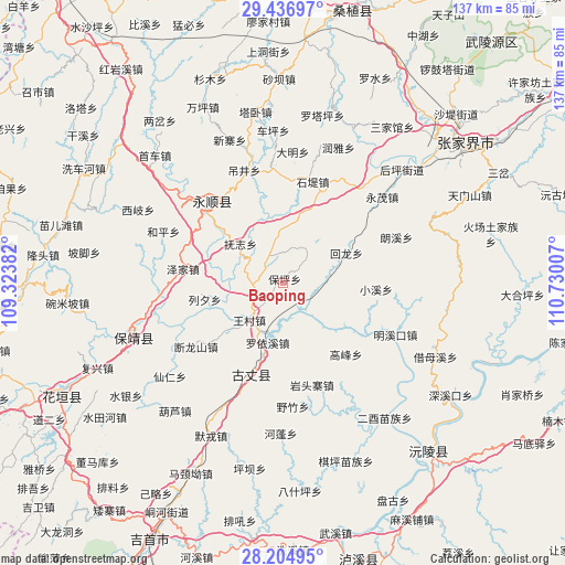
Baoping GPS coordinates[2]
28° 49' 22.008" North, 110° 1' 36.984" East
| Map corner | latitude | longitude |
|---|---|---|
| Upper-left | 29.43697°, | 109.32382° |
| Center: | 28.82278°, | 110.02694° |
| Lower-right: | 28.20495°, | 110.73007° |
| Map W x H: | 137×137 km | = 85.1×85.1mi |
| max Lat: | 53.31946° ⇑67% North |
| Baoping: | 28.82278° |
| min Lat: | ⇓33% South 18.22056° |
| min Long | Baoping | max Long |
| 75.07348° | 110.02694° | 134.28917° |
| W 28.9%⇐ | ⇒71.1% E |
Elevation
Elevation of Baoping is 561 m = 1841 ft, and this is 76.2 m = 250 ft above average elevation for this country.
| Max E: |
5622 m = 18445 ft | 23.5% |
| Baoping | 561 m 1841 ft | |
| Avg. | 484.8 m = 1591 ft | |
Min E: |
-3 m = -10 ft | 76.5% |
See also: China elevation on elevation.city.
Geographical zone
Baoping is located in North temperate zone (between Tropic of Cancer and the Arctic Circle). Distance of this Northern Tropic circle is 598.9 km =372.1 mi to South.| Distance of | km | miles | from Baoping |
|---|---|---|---|
| North Pole | 6802.3 | 4226.8 | to North |
| Arctic Circle | 4196.4 | 2607.5 | to North |
| Tropic Cancer | 598.9 | 372.1 | to South |
| Equator | 3204.8 | 1991.4 | to South |


Nearby cities:
15 places around Baoping: (largest is in red/bold)
• Daba
25.3 km =15.7 mi,  299°
299°
• Duanlongshan
26.2 km =16.3 mi,  233°
233°
• Fuzhiping
12.9 km =8 mi,  308°
308°
• Gaofeng
23.1 km =14.4 mi,  138°
138°
• Guyang
25 km =15.5 mi,  201°
201°
• Huilongan
16.8 km =10.4 mi,  63°
63°
• Liandonggang
24.9 km =15.5 mi,  325°
325°
• Liexi
19.4 km =12.1 mi,  257°
257°
• Macha
24.5 km =15.2 mi,  4°
4°
• Qietong
19.2 km =11.9 mi, 229°
• Shidixi
25.6 km =15.9 mi,  16°
16°
• Shiziqiao
17.9 km =11.1 mi,  13°
13°
• Wangcun
12.2 km =7.6 mi,  221°
221°
• Ximi
10.1 km =6.3 mi,  348°
348°
• Zejia
24.5 km =15.2 mi,  277°
277°
Sources, notices
• [Note1] Compared only with cities in China existing in our database
• [Src1] Map data: © OpenStreetMap contributors (CC-BY-SA)
• [Src2] Other city data from geonames.org with taken over terms of usage.
• [Src3] Geographical zone / Annual Mean Temperature by Robert A. Rohde @ Wikipedia
