Daba geodata
Daba (Hunan) is a seat of a fourth-order administrative division; located in China in Asia/Shanghai (GMT+8) time zone. In our database, there are 1268 cities with bigger population. Compared to other cities in China, 66% of cities are located further ↑North; 72.3% of cities are located further →East and 67.5% of cities have lower elevation than Daba. Note1


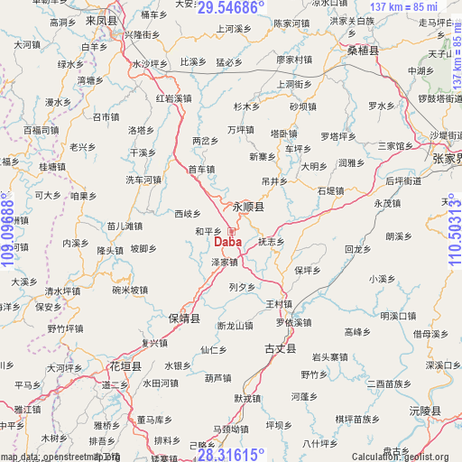
Daba GPS coordinates[2]
28° 55' 59.988" North, 109° 48' 0" East
| Map corner | latitude | longitude |
|---|---|---|
| Upper-left | 29.54686°, | 109.09688° |
| Center: | 28.93333°, | 109.8° |
| Lower-right: | 28.31615°, | 110.50313° |
| Map W x H: | 136.8×136.8 km | = 85×85mi |
| max Lat: | 53.31946° ⇑66% North |
| Daba: | 28.93333° |
| min Lat: | ⇓34% South 18.22056° |
| min Long | Daba | max Long |
| 75.07348° | 109.8° | 134.28917° |
| W 27.7%⇐ | ⇒72.3% E |
Elevation
Elevation of Daba is 367 m = 1204 ft, and this is 117.8 m = 386 ft below average elevation for this country.
| Max E: |
5622 m = 18445 ft | 32.5% |
| Avg. | 484.8 m = 1591 ft | |
| Daba | 367 m = 1204 ft | |
Min E: |
-3 m = -10 ft | 67.5% |
See also: China elevation on elevation.city.
Geographical zone
Daba is located in North temperate zone (between Tropic of Cancer and the Arctic Circle). Distance of this Northern Tropic circle is 611.2 km =379.8 mi to South.| Distance of | km | miles | from Daba |
|---|---|---|---|
| North Pole | 6790 | 4219.1 | to North |
| Arctic Circle | 4184.1 | 2599.9 | to North |
| Tropic Cancer | 611.2 | 379.8 | to South |
| Equator | 3217.1 | 1999 | to South |


Nearby cities:
15 places around Daba: (largest is in red/bold)
• Baiyang
15.4 km =9.6 mi,  204°
204°
• Dianfang
23 km =14.3 mi,  282°
282°
• Diaojingyan
19.4 km =12.1 mi,  39°
39°
• Duishan
14 km =8.7 mi,  259°
259°
• Fuzhiping
12.7 km =7.9 mi,  109°
109°
• Heping
6.9 km =4.3 mi,  271°
271°
• Liandonggang
11.5 km =7.1 mi, 44°
• Liexi
16.7 km =10.4 mi,  169°
169°
• Lingxi
9.1 km =5.7 mi,  28°
28°
• Purong
19.7 km =12.2 mi,  245°
245°
• Shaoha
10.4 km =6.5 mi,  342°
342°
• Ximi
20.3 km =12.6 mi,  96°
96°
• Xiqi
14.1 km =8.8 mi,  292°
292°
• Yanbanpu
17.9 km =11.1 mi,  10°
10°
• Zejia
9.2 km =5.7 mi,  193°
193°
Sources, notices
• [Note1] Compared only with cities in China existing in our database
• [Src1] Map data: © OpenStreetMap contributors (CC-BY-SA)
• [Src2] Other city data from geonames.org with taken over terms of usage.
• [Src3] Geographical zone / Annual Mean Temperature by Robert A. Rohde @ Wikipedia
