Lingfang geodata
Lingfang (Hunan) is a seat of a fourth-order administrative division; located in China in Asia/Shanghai (GMT+8) time zone. In our database, there are 1268 cities with bigger population. Compared to other cities in China, 79.6% of cities are located further ↑North; 53.6% of cities are located further →East and 55.1% of cities have higher elevation than Lingfang. Note1


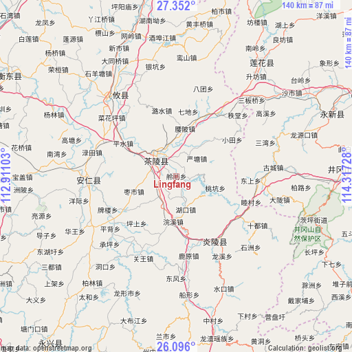
Lingfang GPS coordinates[2]
26° 43' 32.628" North, 113° 36' 50.94" East
| Map corner | latitude | longitude |
|---|---|---|
| Upper-left | 27.352°, | 112.91103° |
| Center: | 26.72573°, | 113.61415° |
| Lower-right: | 26.096°, | 114.31728° |
| Map W x H: | 139.7×139.7 km | = 86.8×86.8mi |
| max Lat: | 53.31946° ⇑79.6% North |
| Lingfang: | 26.72573° |
| min Lat: | ⇓20.4% South 18.22056° |
| min Long | Lingfang | max Long |
| 75.07348° | 113.61415° | 134.28917° |
| W 46.4%⇐ | ⇒53.6% E |
Elevation
Elevation of Lingfang is 131 m = 430 ft, and this is 353.8 m = 1161 ft below average elevation for this country.
| Max E: |
5622 m = 18445 ft | 55.1% |
| Avg. | 484.8 m = 1591 ft | |
| Lingfang | 131 m = 430 ft | |
Min E: |
-3 m = -10 ft | 44.9% |
See also: China elevation on elevation.city.
Geographical zone
Lingfang is located in North temperate zone (between Tropic of Cancer and the Arctic Circle). Distance of this Northern Tropic circle is 365.7 km =227.2 mi to South.| Distance of | km | miles | from Lingfang |
|---|---|---|---|
| North Pole | 7035.4 | 4371.6 | to North |
| Arctic Circle | 4429.6 | 2752.4 | to North |
| Tropic Cancer | 365.7 | 227.2 | to South |
| Equator | 2971.6 | 1846.5 | to South |


Nearby cities:
15 places around Lingfang: (largest is in red/bold)
• Chaling Chengguanzhen
10.4 km =6.5 mi,  314°
314°
• Huanxi
18.1 km =11.2 mi,  184°
184°
• Hukou
13.8 km =8.6 mi,  164°
164°
• Jiangkou
19.7 km =12.2 mi,  112°
112°
• Jieshou
24.6 km =15.3 mi,  237°
237°
• Majiang
7.5 km =4.7 mi,  257°
257°
• Mijiang
9.4 km =5.8 mi,  321°
321°
• Pingshui
24.8 km =15.4 mi,  301°
301°
• Sicong
12 km =7.5 mi, 324°
• Taokeng
14.9 km =9.3 mi,  115°
115°
• Xiadong
9.8 km =6.1 mi, 303°
• Yantang
10.7 km =6.6 mi,  49°
49°
• Yaopi
19.1 km =11.9 mi,  10°
10°
• Yaoshui
13.1 km =8.1 mi,  32°
32°
• Zaoshi
17.9 km =11.1 mi,  250°
250°
Sources, notices
• [Note1] Compared only with cities in China existing in our database
• [Src1] Map data: © OpenStreetMap contributors (CC-BY-SA)
• [Src2] Other city data from geonames.org with taken over terms of usage.
• [Src3] Geographical zone / Annual Mean Temperature by Robert A. Rohde @ Wikipedia
