Huju geodata
Huju (Hunan) is a seat of a fourth-order administrative division; located in China in Asia/Shanghai (GMT+8) time zone. In our database, there are 1268 cities with bigger population. Compared to other cities in China, 78.9% of cities are located further ↑North; 55% of cities are located further →East and 60.4% of cities have higher elevation than Huju. Note1


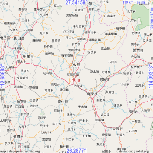
Huju GPS coordinates[2]
26° 54' 59.004" North, 113° 23' 24" East
| Map corner | latitude | longitude |
|---|---|---|
| Upper-left | 27.54159°, | 112.68688° |
| Center: | 26.91639°, | 113.39° |
| Lower-right: | 26.2877°, | 114.09313° |
| Map W x H: | 139.4×139.4 km | = 86.6×86.6mi |
| max Lat: | 53.31946° ⇑78.9% North |
| Huju: | 26.91639° |
| min Lat: | ⇓21.1% South 18.22056° |
| min Long | Huju | max Long |
| 75.07348° | 113.39° | 134.28917° |
| W 45%⇐ | ⇒55% E |
Elevation
Elevation of Huju is 96 m = 315 ft, and this is 388.8 m = 1276 ft below average elevation for this country.
| Max E: |
5622 m = 18445 ft | 60.4% |
| Avg. | 484.8 m = 1591 ft | |
| Huju | 96 m = 315 ft | |
Min E: |
-3 m = -10 ft | 39.6% |
See also: China elevation on elevation.city.
Geographical zone
Huju is located in North temperate zone (between Tropic of Cancer and the Arctic Circle). Distance of this Northern Tropic circle is 386.9 km =240.4 mi to South.| Distance of | km | miles | from Huju |
|---|---|---|---|
| North Pole | 7014.2 | 4358.4 | to North |
| Arctic Circle | 4408.4 | 2739.3 | to North |
| Tropic Cancer | 386.9 | 240.4 | to South |
| Equator | 2992.8 | 1859.6 | to South |


Nearby cities:
15 places around Huju: (largest is in red/bold)
• Anren Chengguanzhen
25.6 km =15.9 mi,  208°
208°
• Chaling Chengguanzhen
20.4 km =12.7 mi,  133°
133°
• Lingfang
30.7 km =19.1 mi, 133°
• Lushui
17.1 km =10.6 mi,  73°
73°
• Majiang
27.2 km =16.9 mi,  146°
146°
• Mijiang
21.5 km =13.4 mi, 130°
• Pingshui
8.2 km =5.1 mi,  172°
172°
• Qidi
27.3 km =17 mi,  80°
80°
• Sicong
19.1 km =11.9 mi, 126°
• Xiadong
21.1 km =13.1 mi,  138°
138°
• Yantang
33.5 km =20.8 mi,  115°
115°
• Yaopi
25.8 km =16 mi,  95°
95°
• Yaoshui
31 km =19.3 mi,  109°
109°
• Youxian Chengguanzhen
8.9 km =5.5 mi,  340°
340°
• Zaoshi
27.8 km =17.3 mi, 168°
Sources, notices
• [Note1] Compared only with cities in China existing in our database
• [Src1] Map data: © OpenStreetMap contributors (CC-BY-SA)
• [Src2] Other city data from geonames.org with taken over terms of usage.
• [Src3] Geographical zone / Annual Mean Temperature by Robert A. Rohde @ Wikipedia
