Jitoucun geodata
Jitoucun (Fujian) is a populated place; located in China in Asia/Shanghai (GMT+8) time zone. With population of 1,700 people, there are 1063 cities with bigger population in this country. Compared to other cities in China, 80.6% of cities are located further ↑North; 79.5% of cities are located further ←West and 98.9% of cities have higher elevation than Jitoucun. Note1


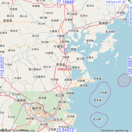
Jitoucun GPS coordinates[2]
26° 28' 36.516" North, 119° 36' 18.612" East
| Map corner | latitude | longitude |
|---|---|---|
| Upper-left | 27.10446°, | 118.90205° |
| Center: | 26.47681°, | 119.60517° |
| Lower-right: | 25.84572°, | 120.3083° |
| Map W x H: | 140×140 km | = 87×87mi |
| max Lat: | 53.31946° ⇑80.6% North |
| Jitoucun: | 26.47681° |
| min Lat: | ⇓19.4% South 18.22056° |
| min Long | Jitoucun | max Long |
| 75.07348° | 119.60517° | 134.28917° |
| W 79.5%⇐ | ⇒20.5% E |
Elevation
Elevation of Jitoucun is 3 m = 10 ft, and this is 481.8 m = 1581 ft below average elevation for this country.
| Max E: |
5622 m = 18445 ft | 98.9% |
| Avg. | 484.8 m = 1591 ft | |
| Jitoucun | 3 m = 10 ft | |
Min E: |
-3 m = -10 ft | 1.1% |
See also: China elevation on elevation.city.
Geographical zone
Jitoucun is located in North temperate zone (between Tropic of Cancer and the Arctic Circle). Distance of this Northern Tropic circle is 338 km =210 mi to South.| Distance of | km | miles | from Jitoucun |
|---|---|---|---|
| North Pole | 7063.1 | 4388.8 | to North |
| Arctic Circle | 4457.2 | 2769.6 | to North |
| Tropic Cancer | 338 | 210 | to South |
| Equator | 2943.9 | 1829.3 | to South |


Nearby cities:
15 places around Jitoucun: (largest is in red/bold)
• Beishancun
5.2 km =3.2 mi,  147°
147°
• Changlong
17.9 km =11.1 mi,  191°
191°
• Danyang
18.7 km =11.6 mi,  221°
221°
• Feiluan
9.6 km =6 mi,  355°
355°
• Fengshan
5.7 km =3.5 mi,  279°
279°
• Guanban
19.4 km =12.1 mi,  160°
160°
• Hongyang
15.3 km =9.5 mi,  292°
292°
• Jianjiang
17 km =10.6 mi,  61°
61°
• Lian’aocun
18.4 km =11.4 mi,  100°
100°
• Liaoyan
21.7 km =13.5 mi,  236°
236°
• Mabi
12.4 km =7.7 mi, 155°
• Qibu
6.9 km =4.3 mi,  299°
299°
• Songqi
19.1 km =11.9 mi,  19°
19°
• Toubao
14.4 km =8.9 mi,  171°
171°
• Xiagong
21.6 km =13.4 mi,  118°
118°
Sources, notices
• [Note1] Compared only with cities in China existing in our database
• [Src1] Map data: © OpenStreetMap contributors (CC-BY-SA)
• [Src2] Other city data from geonames.org with taken over terms of usage.
• [Src3] Geographical zone / Annual Mean Temperature by Robert A. Rohde @ Wikipedia
