Changlong geodata
Changlong (Fujian) is a seat of a fourth-order administrative division; located in China in Asia/Shanghai (GMT+8) time zone. In our database, there are 1268 cities with bigger population. Compared to other cities in China, 81.1% of cities are located further ↑North; 79.3% of cities are located further ←West and 68.3% of cities have lower elevation than Changlong. Note1


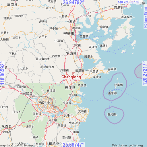
Changlong GPS coordinates[2]
26° 19' 9.876" North, 119° 34' 8.544" East
| Map corner | latitude | longitude |
|---|---|---|
| Upper-left | 26.94792°, | 118.86592° |
| Center: | 26.31941°, | 119.56904° |
| Lower-right: | 25.68747°, | 120.27217° |
| Map W x H: | 140.1×140.2 km | = 87.1×87.1mi |
| max Lat: | 53.31946° ⇑81.1% North |
| Changlong: | 26.31941° |
| min Lat: | ⇓18.9% South 18.22056° |
| min Long | Changlong | max Long |
| 75.07348° | 119.56904° | 134.28917° |
| W 79.3%⇐ | ⇒20.7% E |
Elevation
Elevation of Changlong is 382 m = 1253 ft, and this is 102.8 m = 337 ft below average elevation for this country.
| Max E: |
5622 m = 18445 ft | 31.7% |
| Avg. | 484.8 m = 1591 ft | |
| Changlong | 382 m = 1253 ft | |
Min E: |
-3 m = -10 ft | 68.3% |
See also: China elevation on elevation.city.
Geographical zone
Changlong is located in North temperate zone (between Tropic of Cancer and the Arctic Circle). Distance of this Northern Tropic circle is 320.5 km =199.1 mi to South.| Distance of | km | miles | from Changlong |
|---|---|---|---|
| North Pole | 7080.6 | 4399.7 | to North |
| Arctic Circle | 4474.7 | 2780.4 | to North |
| Tropic Cancer | 320.5 | 199.1 | to South |
| Equator | 2926.4 | 1818.4 | to South |


Nearby cities:
15 places around Changlong: (largest is in red/bold)
• Aojiang
13.5 km =8.4 mi,  194°
194°
• Beishancun
14.6 km =9.1 mi,  26°
26°
• Danyang
9.5 km =5.9 mi,  291°
291°
• Dongdai
9.6 km =6 mi,  151°
151°
• Donghu
10.9 km =6.8 mi,  210°
210°
• Fengcheng
13.9 km =8.6 mi, 192°
• Guanban
10.1 km =6.3 mi,  94°
94°
• Jiangnan
14.4 km =8.9 mi, 192°
• Jitoucun
17.9 km =11.1 mi,  11°
11°
• Liaoyan
15.5 km =9.6 mi, 290°
• Mabi
10.7 km =6.6 mi,  54°
54°
• Pandu
15 km =9.3 mi,  232°
232°
• Pukou
8.4 km =5.2 mi,  160°
160°
• Toubao
6.5 km =4 mi,  60°
60°
• Xiao’ao
13.6 km =8.5 mi,  144°
144°
Sources, notices
• [Note1] Compared only with cities in China existing in our database
• [Src1] Map data: © OpenStreetMap contributors (CC-BY-SA)
• [Src2] Other city data from geonames.org with taken over terms of usage.
• [Src3] Geographical zone / Annual Mean Temperature by Robert A. Rohde @ Wikipedia
