Beishancun geodata
Beishancun (Fujian) is a populated place; located in China in Asia/Shanghai (GMT+8) time zone. With population of 3,720 people, there are 910 cities with bigger population in this country. Compared to other cities in China, 80.7% of cities are located further ↑North; 79.6% of cities are located further ←West and 91.2% of cities have higher elevation than Beishancun. Note1


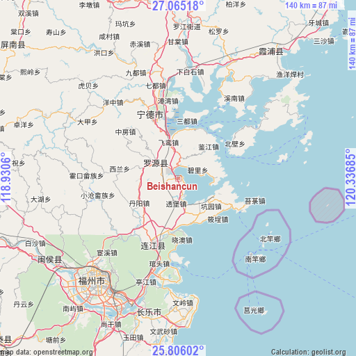
Beishancun GPS coordinates[2]
26° 26' 14.352" North, 119° 38' 1.392" East
| Map corner | latitude | longitude |
|---|---|---|
| Upper-left | 27.06518°, | 118.9306° |
| Center: | 26.43732°, | 119.63372° |
| Lower-right: | 25.80602°, | 120.33685° |
| Map W x H: | 140×140 km | = 87×87mi |
| max Lat: | 53.31946° ⇑80.7% North |
| Beishancun: | 26.43732° |
| min Lat: | ⇓19.3% South 18.22056° |
| min Long | Beishancun | max Long |
| 75.07348° | 119.63372° | 134.28917° |
| W 79.6%⇐ | ⇒20.4% E |
Elevation
Elevation of Beishancun is 9 m = 30 ft, and this is 475.8 m = 1561 ft below average elevation for this country.
| Max E: |
5622 m = 18445 ft | 91.2% |
| Avg. | 484.8 m = 1591 ft | |
| Beishancun | 9 m = 30 ft | |
Min E: |
-3 m = -10 ft | 8.8% |
See also: China elevation on elevation.city.
Geographical zone
Beishancun is located in North temperate zone (between Tropic of Cancer and the Arctic Circle). Distance of this Northern Tropic circle is 333.6 km =207.3 mi to South.| Distance of | km | miles | from Beishancun |
|---|---|---|---|
| North Pole | 7067.5 | 4391.5 | to North |
| Arctic Circle | 4461.6 | 2772.3 | to North |
| Tropic Cancer | 333.6 | 207.3 | to South |
| Equator | 2939.6 | 1826.6 | to South |


Nearby cities:
15 places around Beishancun: (largest is in red/bold)
• Changlong
14.6 km =9.1 mi,  206°
206°
• Danyang
18 km =11.2 mi,  237°
237°
• Feiluan
14.4 km =8.9 mi,  345°
345°
• Fengshan
10 km =6.2 mi,  302°
302°
• Guanban
14.4 km =8.9 mi,  165°
165°
• Hongyang
19.8 km =12.3 mi, 300°
• Jianjiang
17.4 km =10.8 mi,  44°
44°
• Jitoucun
5.2 km =3.2 mi,  327°
327°
• Kengyuan
17 km =10.6 mi,  129°
129°
• Lian’aocun
15.3 km =9.5 mi,  86°
86°
• Mabi
7.2 km =4.5 mi,  162°
162°
• Pukou
21.3 km =13.2 mi,  189°
189°
• Qibu
11.8 km =7.3 mi,  311°
311°
• Toubao
9.9 km =6.2 mi,  184°
184°
• Xiagong
17.1 km =10.6 mi,  110°
110°
Sources, notices
• [Note1] Compared only with cities in China existing in our database
• [Src1] Map data: © OpenStreetMap contributors (CC-BY-SA)
• [Src2] Other city data from geonames.org with taken over terms of usage.
• [Src3] Geographical zone / Annual Mean Temperature by Robert A. Rohde @ Wikipedia
