Zhenxiang geodata
Zhenxiang (Heilongjiang) is a seat of a fourth-order administrative division; located in China in Asia/Shanghai (GMT+8) time zone. In our database, there are 1268 cities with bigger population. Compared to other cities in China, 97% of cities are located further ↓South; 95.3% of cities are located further ←West and 55.4% of cities have lower elevation than Zhenxiang. Note1


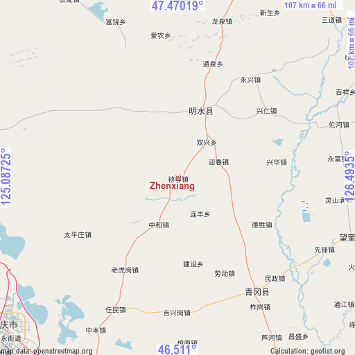
Zhenxiang GPS coordinates[2]
46° 59' 33.9" North, 125° 47' 25.332" East
| Map corner | latitude | longitude |
|---|---|---|
| Upper-left | 47.47019°, | 125.08725° |
| Center: | 46.99275°, | 125.79037° |
| Lower-right: | 46.511°, | 126.4935° |
| Map W x H: | 106.7×106.7 km | = 66.3×66.3mi |
| max Lat: | 53.31946° ⇑3% North |
| Zhenxiang: | 46.99275° |
| min Lat: | ⇓97% South 18.22056° |
| min Long | Zhenxiang | max Long |
| 75.07348° | 125.79037° | 134.28917° |
| W 95.3%⇐ | ⇒4.7% E |
Elevation
Elevation of Zhenxiang is 210 m = 689 ft, and this is 274.8 m = 902 ft below average elevation for this country.
| Max E: |
5622 m = 18445 ft | 44.6% |
| Avg. | 484.8 m = 1591 ft | |
| Zhenxiang | 210 m = 689 ft | |
Min E: |
-3 m = -10 ft | 55.4% |
See also: China elevation on elevation.city.
Geographical zone
Zhenxiang is located in North temperate zone (between Tropic of Cancer and the Arctic Circle). Distance of this North polar circle is 2176.1 km =1352.2 mi to North.| Distance of | km | miles | from Zhenxiang |
|---|---|---|---|
| North Pole | 4782 | 2971.4 | to North |
| Arctic Circle | 2176.1 | 1352.2 | to North |
| Tropic Cancer | 2619.2 | 1627.5 | to South |
| Equator | 5225.1 | 3246.7 | to South |


Nearby cities:
15 places around Zhenxiang: (largest is in red/bold)
• Desheng
29 km =18 mi,  119°
119°
• Jianshe
26.3 km =16.3 mi,  170°
170°
• Laodong
28.5 km =17.7 mi,  157°
157°
• Laohugang
31.9 km =19.8 mi,  209°
209°
• Lianfeng
12.7 km =7.9 mi,  148°
148°
• Mingshui
22.6 km =14 mi,  21°
21°
• Shuangxing
14 km =8.7 mi,  38°
38°
• Tongda
23.3 km =14.5 mi,  329°
329°
• Xincun
18.5 km =11.5 mi,  223°
223°
• Xinghua
30 km =18.6 mi,  80°
80°
• Yingchun
12.8 km =8 mi,  67°
67°
• Yongfeng
21.6 km =13.4 mi,  126°
126°
• Yongjiu
22.4 km =13.9 mi,  47°
47°
• Yulin
19.5 km =12.1 mi,  321°
321°
• Zhonghe
15.1 km =9.4 mi,  202°
202°
Sources, notices
• [Note1] Compared only with cities in China existing in our database
• [Src1] Map data: © OpenStreetMap contributors (CC-BY-SA)
• [Src2] Other city data from geonames.org with taken over terms of usage.
• [Src3] Geographical zone / Annual Mean Temperature by Robert A. Rohde @ Wikipedia
