Lianfeng geodata
Lianfeng (Heilongjiang) is a seat of a fourth-order administrative division; located in China in Asia/Shanghai (GMT+8) time zone. In our database, there are 1268 cities with bigger population. Compared to other cities in China, 96.8% of cities are located further ↓South; 95.4% of cities are located further ←West and 55.3% of cities have lower elevation than Lianfeng. Note1


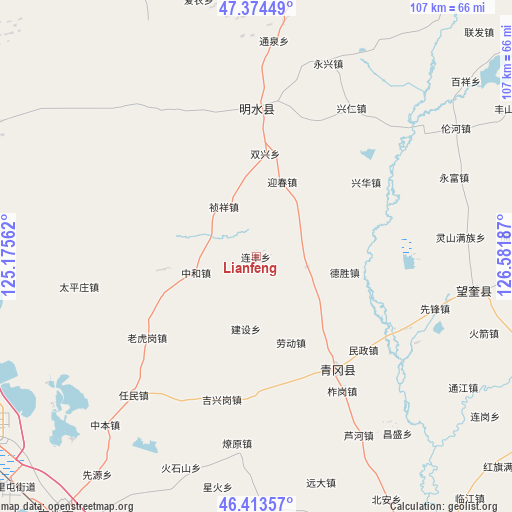
Lianfeng GPS coordinates[2]
46° 53' 46.248" North, 125° 52' 43.464" East
| Map corner | latitude | longitude |
|---|---|---|
| Upper-left | 47.37449°, | 125.17562° |
| Center: | 46.89618°, | 125.87874° |
| Lower-right: | 46.41357°, | 126.58187° |
| Map W x H: | 106.8×106.8 km | = 66.4×66.4mi |
| max Lat: | 53.31946° ⇑3.2% North |
| Lianfeng: | 46.89618° |
| min Lat: | ⇓96.8% South 18.22056° |
| min Long | Lianfeng | max Long |
| 75.07348° | 125.87874° | 134.28917° |
| W 95.4%⇐ | ⇒4.6% E |
Elevation
Elevation of Lianfeng is 209 m = 686 ft, and this is 275.8 m = 905 ft below average elevation for this country.
| Max E: |
5622 m = 18445 ft | 44.7% |
| Avg. | 484.8 m = 1591 ft | |
| Lianfeng | 209 m = 686 ft | |
Min E: |
-3 m = -10 ft | 55.3% |
See also: China elevation on elevation.city.
Geographical zone
Lianfeng is located in North temperate zone (between Tropic of Cancer and the Arctic Circle). Distance of this North polar circle is 2186.8 km =1358.8 mi to North.| Distance of | km | miles | from Lianfeng |
|---|---|---|---|
| North Pole | 4792.7 | 2978 | to North |
| Arctic Circle | 2186.8 | 1358.8 | to North |
| Tropic Cancer | 2608.4 | 1620.8 | to South |
| Equator | 5214.4 | 3240.1 | to South |


Nearby cities:
15 places around Lianfeng: (largest is in red/bold)
• Desheng
18.9 km =11.7 mi,  100°
100°
• Jianshe
15.4 km =9.6 mi,  189°
189°
• Jixinggang
30.7 km =19.1 mi, 193°
• Laodong
16.2 km =10.1 mi,  165°
165°
• Laohugang
28.2 km =17.5 mi,  233°
233°
• Minzheng
29.8 km =18.5 mi,  131°
131°
• Qinggang
29.2 km =18.1 mi,  143°
143°
• Shuangxing
21.7 km =13.5 mi,  5°
5°
• Xincun
19.7 km =12.2 mi,  262°
262°
• Xinghua
27.8 km =17.3 mi,  55°
55°
• Yingchun
16.5 km =10.3 mi,  18°
18°
• Yongfeng
10.9 km =6.8 mi, 100°
• Yongjiu
27.6 km =17.1 mi, 21°
• Zhenxiang
12.7 km =7.9 mi,  328°
328°
• Zhonghe
13 km =8.1 mi, 255°
Sources, notices
• [Note1] Compared only with cities in China existing in our database
• [Src1] Map data: © OpenStreetMap contributors (CC-BY-SA)
• [Src2] Other city data from geonames.org with taken over terms of usage.
• [Src3] Geographical zone / Annual Mean Temperature by Robert A. Rohde @ Wikipedia
