Laodong geodata
Laodong (Heilongjiang) is a seat of a fourth-order administrative division; located in China in Asia/Shanghai (GMT+8) time zone. In our database, there are 1268 cities with bigger population. Compared to other cities in China, 96.4% of cities are located further ↓South; 95.5% of cities are located further ←West and 55.6% of cities have lower elevation than Laodong. Note1


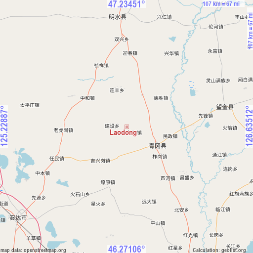
Laodong GPS coordinates[2]
46° 45' 17.784" North, 125° 55' 55.164" East
| Map corner | latitude | longitude |
|---|---|---|
| Upper-left | 47.23451°, | 125.22887° |
| Center: | 46.75494°, | 125.93199° |
| Lower-right: | 46.27106°, | 126.63512° |
| Map W x H: | 107.1×107.1 km | = 66.5×66.5mi |
| max Lat: | 53.31946° ⇑3.6% North |
| Laodong: | 46.75494° |
| min Lat: | ⇓96.4% South 18.22056° |
| min Long | Laodong | max Long |
| 75.07348° | 125.93199° | 134.28917° |
| W 95.5%⇐ | ⇒4.5% E |
Elevation
Elevation of Laodong is 212 m = 696 ft, and this is 272.8 m = 895 ft below average elevation for this country.
| Max E: |
5622 m = 18445 ft | 44.4% |
| Avg. | 484.8 m = 1591 ft | |
| Laodong | 212 m = 696 ft | |
Min E: |
-3 m = -10 ft | 55.6% |
See also: China elevation on elevation.city.
Geographical zone
Laodong is located in North temperate zone (between Tropic of Cancer and the Arctic Circle). Distance of this North polar circle is 2202.5 km =1368.6 mi to North.| Distance of | km | miles | from Laodong |
|---|---|---|---|
| North Pole | 4808.4 | 2987.8 | to North |
| Arctic Circle | 2202.5 | 1368.6 | to North |
| Tropic Cancer | 2592.7 | 1611 | to South |
| Equator | 5198.7 | 3230.3 | to South |


Nearby cities:
15 places around Laodong: (largest is in red/bold)
• Desheng
19.2 km =11.9 mi,  49°
49°
• Jianshe
6.5 km =4 mi,  274°
274°
• Jixinggang
18.1 km =11.2 mi,  218°
218°
• Laohugang
26.8 km =16.7 mi, 267°
• Lianfeng
16.2 km =10.1 mi,  345°
345°
• Liaoyuan
24.7 km =15.3 mi,  198°
198°
• Luhe
27.7 km =17.2 mi,  140°
140°
• Minzheng
18.8 km =11.7 mi,  101°
101°
• Qinggang
15.4 km =9.6 mi,  120°
120°
• Xincun
27 km =16.8 mi,  298°
298°
• Yingchun
31.4 km =19.5 mi,  2°
2°
• Yongfeng
15.2 km =9.4 mi,  25°
25°
• Zhagang
18.7 km =11.6 mi,  130°
130°
• Zhenxiang
28.5 km =17.7 mi,  337°
337°
• Zhonghe
20.8 km =12.9 mi,  306°
306°
Sources, notices
• [Note1] Compared only with cities in China existing in our database
• [Src1] Map data: © OpenStreetMap contributors (CC-BY-SA)
• [Src2] Other city data from geonames.org with taken over terms of usage.
• [Src3] Geographical zone / Annual Mean Temperature by Robert A. Rohde @ Wikipedia
