Xinghua geodata
Xinghua (Heilongjiang) is a seat of a fourth-order administrative division; located in China in Asia/Shanghai (GMT+8) time zone. In our database, there are 1268 cities with bigger population. Compared to other cities in China, 97% of cities are located further ↓South; 95.7% of cities are located further ←West and 51.5% of cities have lower elevation than Xinghua. Note1


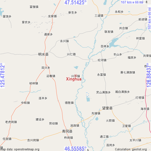
Xinghua GPS coordinates[2]
47° 2' 13.92" North, 126° 10' 52.464" East
| Map corner | latitude | longitude |
|---|---|---|
| Upper-left | 47.51425°, | 125.47812° |
| Center: | 47.0372°, | 126.18124° |
| Lower-right: | 46.55585°, | 126.88437° |
| Map W x H: | 106.6×106.6 km | = 66.2×66.2mi |
| max Lat: | 53.31946° ⇑3% North |
| Xinghua: | 47.0372° |
| min Lat: | ⇓97% South 18.22056° |
| min Long | Xinghua | max Long |
| 75.07348° | 126.18124° | 134.28917° |
| W 95.7%⇐ | ⇒4.3% E |
Elevation
Elevation of Xinghua is 177 m = 581 ft, and this is 307.8 m = 1010 ft below average elevation for this country.
| Max E: |
5622 m = 18445 ft | 48.5% |
| Avg. | 484.8 m = 1591 ft | |
| Xinghua | 177 m = 581 ft | |
Min E: |
-3 m = -10 ft | 51.5% |
See also: China elevation on elevation.city.
Geographical zone
Xinghua is located in North temperate zone (between Tropic of Cancer and the Arctic Circle). Distance of this North polar circle is 2171.1 km =1349.1 mi to North.| Distance of | km | miles | from Xinghua |
|---|---|---|---|
| North Pole | 4777 | 2968.3 | to North |
| Arctic Circle | 2171.1 | 1349.1 | to North |
| Tropic Cancer | 2624.1 | 1630.5 | to South |
| Equator | 5230 | 3249.8 | to South |


Nearby cities:
15 places around Xinghua: (largest is in red/bold)
• Baixiang
29.1 km =18.1 mi,  44°
44°
• Desheng
19.5 km =12.1 mi,  192°
192°
• Housan
18 km =11.2 mi,  134°
134°
• Lianfeng
27.8 km =17.3 mi,  235°
235°
• Lingshan
23 km =14.3 mi,  120°
120°
• Lunhe
21.8 km =13.5 mi,  59°
59°
• Mingshui
26.6 km =16.5 mi,  307°
307°
• Shuangxing
21.7 km =13.5 mi,  285°
285°
• Shuren
14 km =8.7 mi,  12°
12°
• Xingren
15.6 km =9.7 mi,  349°
349°
• Yingchun
17.8 km =11.1 mi,  270°
270°
• Yongfeng
21.6 km =13.4 mi,  214°
214°
• Yongfu
18.4 km =11.4 mi,  87°
87°
• Yongjiu
16.4 km =10.2 mi, 307°
• Yongxing
25.9 km =16.1 mi,  342°
342°
Sources, notices
• [Note1] Compared only with cities in China existing in our database
• [Src1] Map data: © OpenStreetMap contributors (CC-BY-SA)
• [Src2] Other city data from geonames.org with taken over terms of usage.
• [Src3] Geographical zone / Annual Mean Temperature by Robert A. Rohde @ Wikipedia
