Heishan geodata
Heishan (Liaoning) is a populated place; located in China in Asia/Shanghai (GMT+8) time zone. With population of 68,603 people, there are 622 cities with bigger population in this country. Compared to other cities in China, 90.4% of cities are located further ↓South; 91.3% of cities are located further ←West and 80.2% of cities have higher elevation than Heishan. Note1


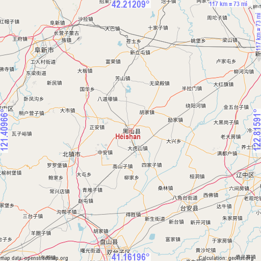
Heishan GPS coordinates[2]
41° 41' 21.012" North, 122° 6' 46.008" East
| Map corner | latitude | longitude |
|---|---|---|
| Upper-left | 42.21209°, | 121.40966° |
| Center: | 41.68917°, | 122.11278° |
| Lower-right: | 41.16196°, | 122.81591° |
| Map W x H: | 116.8×116.8 km | = 72.6×72.6mi |
| max Lat: | 53.31946° ⇑9.6% North |
| Heishan: | 41.68917° |
| min Lat: | ⇓90.4% South 18.22056° |
| min Long | Heishan | max Long |
| 75.07348° | 122.11278° | 134.28917° |
| W 91.3%⇐ | ⇒8.7% E |
Elevation
Elevation of Heishan is 26 m = 85 ft, and this is 458.8 m = 1505 ft below average elevation for this country.
| Max E: |
5622 m = 18445 ft | 80.2% |
| Avg. | 484.8 m = 1591 ft | |
| Heishan | 26 m = 85 ft | |
Min E: |
-3 m = -10 ft | 19.8% |
See also: Heishan elevation on elevation.city.
Geographical zone
Heishan is located in North temperate zone (between Tropic of Cancer and the Arctic Circle). Distance of this Northern Tropic circle is 2029.5 km =1261.1 mi to South.| Distance of | km | miles | from Heishan |
|---|---|---|---|
| North Pole | 5371.7 | 3337.8 | to North |
| Arctic Circle | 2765.8 | 1718.6 | to North |
| Tropic Cancer | 2029.5 | 1261.1 | to South |
| Equator | 4635.4 | 2880.3 | to South |


Nearby cities:
15 places around Heishan: (largest is in red/bold)
• Baojia
39.5 km =24.5 mi,  237°
237°
• Beizhen
28.2 km =17.5 mi,  248°
248°
• Changxingdian
41.8 km =26 mi,  230°
230°
• Dashi
29.9 km =18.6 mi,  288°
288°
• Futun
28.2 km =17.5 mi,  256°
256°
• Gaoshanzi
16.6 km =10.3 mi,  198°
198°
• Goubangzi
45.5 km =28.3 mi,  218°
218°
• Liaotun
36.6 km =22.7 mi, 231°
• Liujia
21 km =13 mi,  179°
179°
• Luoluopu
36.4 km =22.6 mi, 245°
• Qingduizi
32 km =19.9 mi,  212°
212°
• Wujia
27.3 km =17 mi, 200°
• Zhaotun
37.1 km =23.1 mi, 212°
• Zheng’an
15.2 km =9.4 mi,  276°
276°
• Zhong’an
14.5 km =9 mi, 229°
Sources, notices
• [Note1] Compared only with cities in China existing in our database
• [Src1] Map data: © OpenStreetMap contributors (CC-BY-SA)
• [Src2] Other city data from geonames.org with taken over terms of usage.
• [Src3] Geographical zone / Annual Mean Temperature by Robert A. Rohde @ Wikipedia
