Zhalantun geodata
Zhalantun (Inner Mongolia) is a seat of a third-order administrative division; located in China in Asia/Shanghai (GMT+8) time zone. With population of 132,224 people, there are 330 cities with bigger population in this country. Compared to other cities in China, 98.6% of cities are located further ↓South; 92.4% of cities are located further ←West and 64.7% of cities have lower elevation than Zhalantun. Note1


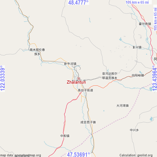
Zhalantun GPS coordinates[2]
48° 0' 34.02" North, 122° 44' 11.436" East
| Map corner | latitude | longitude |
|---|---|---|
| Upper-left | 48.4777°, | 122.03339° |
| Center: | 48.00945°, | 122.73651° |
| Lower-right: | 47.53691°, | 123.43964° |
| Map W x H: | 104.6×104.6 km | = 65×65mi |
| max Lat: | 53.31946° ⇑1.4% North |
| Zhalantun: | 48.00945° |
| min Lat: | ⇓98.6% South 18.22056° |
| min Long | Zhalantun | max Long |
| 75.07348° | 122.73651° | 134.28917° |
| W 92.4%⇐ | ⇒7.6% E |
Elevation
Elevation of Zhalantun is 320 m = 1050 ft, and this is 164.8 m = 541 ft below average elevation for this country.
| Max E: |
5622 m = 18445 ft | 35.3% |
| Avg. | 484.8 m = 1591 ft | |
| Zhalantun | 320 m = 1050 ft | |
Min E: |
-3 m = -10 ft | 64.7% |
See also: Zhalantun elevation on elevation.city.
Geographical zone
Zhalantun is located in North temperate zone (between Tropic of Cancer and the Arctic Circle). Distance of this North polar circle is 2063 km =1281.9 mi to North.| Distance of | km | miles | from Zhalantun |
|---|---|---|---|
| North Pole | 4668.9 | 2901.1 | to North |
| Arctic Circle | 2063 | 1281.9 | to North |
| Tropic Cancer | 2732.2 | 1697.7 | to South |
| Equator | 5338.2 | 3317 | to South |


Nearby cities:
15 places around Zhalantun: (largest is in red/bold)
• Balin
45.2 km =28.1 mi,  317°
317°
• Dahewan
34.2 km =21.3 mi,  121°
121°
• Dawo’er Minzu
19.6 km =12.2 mi,  88°
88°
• Elunchun Minzu
33.2 km =20.6 mi,  303°
303°
• Fuxing
44 km =27.3 mi,  61°
61°
• Halasu
26.2 km =16.3 mi, 295°
• Honghualiangzi
39.6 km =24.6 mi,  73°
73°
• Qinggis Han
29.7 km =18.5 mi,  165°
165°
• Sandaogou
48.9 km =30.4 mi, 89°
• Woniuhe
11.7 km =7.3 mi,  330°
330°
• Xinghua
2.9 km =1.8 mi,  281°
281°
• Ya’ergenchu
30.8 km =19.1 mi,  198°
198°
• Yinhedahan’er
20.5 km =12.7 mi,  84°
84°
• Zhonghe
39.3 km =24.4 mi,  194°
194°
• Zhongxing
50.4 km =31.3 mi,  132°
132°
Sources, notices
• [Note1] Compared only with cities in China existing in our database
• [Src1] Map data: © OpenStreetMap contributors (CC-BY-SA)
• [Src2] Other city data from geonames.org with taken over terms of usage.
• [Src3] Geographical zone / Annual Mean Temperature by Robert A. Rohde @ Wikipedia
