Zhonghe geodata
Zhonghe (Inner Mongolia) is a seat of a fourth-order administrative division; located in China in Asia/Shanghai (GMT+8) time zone. In our database, there are 1268 cities with bigger population. Compared to other cities in China, 98.2% of cities are located further ↓South; 92.3% of cities are located further ←West and 62.6% of cities have lower elevation than Zhonghe. Note1


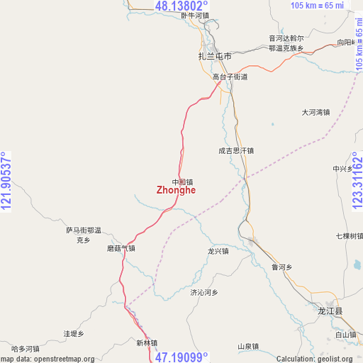
Zhonghe GPS coordinates[2]
47° 39' 59.94" North, 122° 36' 30.564" East
| Map corner | latitude | longitude |
|---|---|---|
| Upper-left | 48.13802°, | 121.90537° |
| Center: | 47.66665°, | 122.60849° |
| Lower-right: | 47.19099°, | 123.31162° |
| Map W x H: | 105.3×105.3 km | = 65.4×65.4mi |
| max Lat: | 53.31946° ⇑1.8% North |
| Zhonghe: | 47.66665° |
| min Lat: | ⇓98.2% South 18.22056° |
| min Long | Zhonghe | max Long |
| 75.07348° | 122.60849° | 134.28917° |
| W 92.3%⇐ | ⇒7.7% E |
Elevation
Elevation of Zhonghe is 291 m = 955 ft, and this is 193.8 m = 636 ft below average elevation for this country.
| Max E: |
5622 m = 18445 ft | 37.4% |
| Avg. | 484.8 m = 1591 ft | |
| Zhonghe | 291 m = 955 ft | |
Min E: |
-3 m = -10 ft | 62.6% |
See also: China elevation on elevation.city.
Geographical zone
Zhonghe is located in North temperate zone (between Tropic of Cancer and the Arctic Circle). Distance of this North polar circle is 2101.1 km =1305.6 mi to North.| Distance of | km | miles | from Zhonghe |
|---|---|---|---|
| North Pole | 4707 | 2924.8 | to North |
| Arctic Circle | 2101.1 | 1305.6 | to North |
| Tropic Cancer | 2694.1 | 1674 | to South |
| Equator | 5300 | 3293.3 | to South |


Nearby cities:
15 places around Zhonghe: (largest is in red/bold)
• Dahewan
43.8 km =27.2 mi,  62°
62°
• Dawo’er Minzu
48.5 km =30.1 mi,  37°
37°
• Guanmenshan
37.2 km =23.1 mi,  214°
214°
• Moguqi
26.1 km =16.2 mi,  222°
222°
• Nianzishan
26.5 km =16.5 mi,  128°
128°
• Qikeshu
51.2 km =31.8 mi,  107°
107°
• Qinggis Han
19.2 km =11.9 mi, 61°
• Samajie Ewenkeminzu
32.5 km =20.2 mi,  242°
242°
• Woniuhe
48.4 km =30.1 mi,  4°
4°
• Xinghua
39.3 km =24.4 mi,  9°
9°
• Xinlin
47.4 km =29.5 mi,  195°
195°
• Ya’ergenchu
8.8 km =5.5 mi,  359°
359°
• Yinhedahan’er
50 km =31.1 mi, 36°
• Zhalantun
39.3 km =24.4 mi, 14°
• Zhongxing
46.8 km =29.1 mi,  85°
85°
Sources, notices
• [Note1] Compared only with cities in China existing in our database
• [Src1] Map data: © OpenStreetMap contributors (CC-BY-SA)
• [Src2] Other city data from geonames.org with taken over terms of usage.
• [Src3] Geographical zone / Annual Mean Temperature by Robert A. Rohde @ Wikipedia
