Xinghua geodata
Xinghua (Inner Mongolia) is a seat of a third-order administrative division; located in China in Asia/Shanghai (GMT+8) time zone. In our database, there are 1268 cities with bigger population. Compared to other cities in China, 98.6% of cities are located further ↓South; 92.3% of cities are located further ←West and 64.6% of cities have lower elevation than Xinghua. Note1


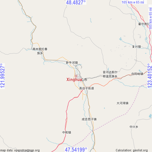
Xinghua GPS coordinates[2]
48° 0' 52.164" North, 122° 41' 54.204" East
| Map corner | latitude | longitude |
|---|---|---|
| Upper-left | 48.4827°, | 121.99527° |
| Center: | 48.01449°, | 122.69839° |
| Lower-right: | 47.54199°, | 123.40152° |
| Map W x H: | 104.6×104.6 km | = 65×65mi |
| max Lat: | 53.31946° ⇑1.4% North |
| Xinghua: | 48.01449° |
| min Lat: | ⇓98.6% South 18.22056° |
| min Long | Xinghua | max Long |
| 75.07348° | 122.69839° | 134.28917° |
| W 92.3%⇐ | ⇒7.7% E |
Elevation
Elevation of Xinghua is 319 m = 1047 ft, and this is 165.8 m = 544 ft below average elevation for this country.
| Max E: |
5622 m = 18445 ft | 35.4% |
| Avg. | 484.8 m = 1591 ft | |
| Xinghua | 319 m = 1047 ft | |
Min E: |
-3 m = -10 ft | 64.6% |
See also: China elevation on elevation.city.
Geographical zone
Xinghua is located in North temperate zone (between Tropic of Cancer and the Arctic Circle). Distance of this North polar circle is 2062.5 km =1281.6 mi to North.| Distance of | km | miles | from Xinghua |
|---|---|---|---|
| North Pole | 4668.4 | 2900.8 | to North |
| Arctic Circle | 2062.5 | 1281.6 | to North |
| Tropic Cancer | 2732.8 | 1698.1 | to South |
| Equator | 5338.7 | 3317.3 | to South |


Nearby cities:
15 places around Xinghua: (largest is in red/bold)
• Balin
42.9 km =26.7 mi,  319°
319°
• Dahewan
36.9 km =22.9 mi,  119°
119°
• Dawo’er Minzu
22.4 km =13.9 mi,  89°
89°
• Elunchun Minzu
30.6 km =19 mi,  305°
305°
• Fuxing
46.3 km =28.8 mi,  63°
63°
• Halasu
23.4 km =14.5 mi,  297°
297°
• Honghualiangzi
42.2 km =26.2 mi,  74°
74°
• Qinggis Han
31.1 km =19.3 mi,  161°
161°
• Sandaogou
51.8 km =32.2 mi, 90°
• Woniuhe
10.1 km =6.3 mi,  342°
342°
• Ya’ergenchu
30.6 km =19 mi,  192°
192°
• Yinhedahan’er
23.3 km =14.5 mi, 86°
• Zhalantun
2.9 km =1.8 mi,  101°
101°
• Zhonghe
39.3 km =24.4 mi, 189°
• Zhongxing
52.9 km =32.9 mi,  131°
131°
Sources, notices
• [Note1] Compared only with cities in China existing in our database
• [Src1] Map data: © OpenStreetMap contributors (CC-BY-SA)
• [Src2] Other city data from geonames.org with taken over terms of usage.
• [Src3] Geographical zone / Annual Mean Temperature by Robert A. Rohde @ Wikipedia
