Fuxing geodata
Fuxing (Inner Mongolia) is a seat of a fourth-order administrative division; located in China in Asia/Shanghai (GMT+8) time zone. In our database, there are 1268 cities with bigger population. Compared to other cities in China, 98.7% of cities are located further ↓South; 92.9% of cities are located further ←West and 59.5% of cities have lower elevation than Fuxing. Note1


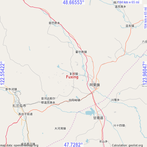
Fuxing GPS coordinates[2]
48° 11' 56.436" North, 123° 15' 26.424" East
| Map corner | latitude | longitude |
|---|---|---|
| Upper-left | 48.66553°, | 122.55422° |
| Center: | 48.19901°, | 123.25734° |
| Lower-right: | 47.7282°, | 123.96047° |
| Map W x H: | 104.2×104.2 km | = 64.7×64.7mi |
| max Lat: | 53.31946° ⇑1.3% North |
| Fuxing: | 48.19901° |
| min Lat: | ⇓98.7% South 18.22056° |
| min Long | Fuxing | max Long |
| 75.07348° | 123.25734° | 134.28917° |
| W 92.9%⇐ | ⇒7.1% E |
Elevation
Elevation of Fuxing is 254 m = 833 ft, and this is 230.8 m = 757 ft below average elevation for this country.
| Max E: |
5622 m = 18445 ft | 40.5% |
| Avg. | 484.8 m = 1591 ft | |
| Fuxing | 254 m = 833 ft | |
Min E: |
-3 m = -10 ft | 59.5% |
See also: China elevation on elevation.city.
Geographical zone
Fuxing is located in North temperate zone (between Tropic of Cancer and the Arctic Circle). Distance of this North polar circle is 2041.9 km =1268.8 mi to North.| Distance of | km | miles | from Fuxing |
|---|---|---|---|
| North Pole | 4647.8 | 2888 | to North |
| Arctic Circle | 2041.9 | 1268.8 | to North |
| Tropic Cancer | 2753.3 | 1710.8 | to South |
| Equator | 5359.2 | 3330.1 | to South |


Nearby cities:
15 places around Fuxing: (largest is in red/bold)
• Dahewan
40.1 km =24.9 mi,  193°
193°
• Dawo’er Minzu
28 km =17.4 mi,  222°
222°
• Gannan
36.5 km =22.7 mi,  149°
149°
• Gushan
40.6 km =25.2 mi,  68°
68°
• Honghualiangzi
9.6 km =6 mi,  184°
184°
• Huo’erqi
16.2 km =10.1 mi,  18°
18°
• Naji
17.2 km =10.7 mi,  119°
119°
• Naketa
22.9 km =14.2 mi,  350°
350°
• Sandaogou
23.2 km =14.4 mi, 153°
• Taipingzhuang
38 km =23.6 mi,  43°
43°
• Woniuhe
45.8 km =28.5 mi,  256°
256°
• Xinglong
35 km =21.7 mi, 122°
• Yinhe
40 km =24.9 mi,  133°
133°
• Yinhedahan’er
26.5 km =16.5 mi, 223°
• Zhalantun
44 km =27.3 mi,  241°
241°
Sources, notices
• [Note1] Compared only with cities in China existing in our database
• [Src1] Map data: © OpenStreetMap contributors (CC-BY-SA)
• [Src2] Other city data from geonames.org with taken over terms of usage.
• [Src3] Geographical zone / Annual Mean Temperature by Robert A. Rohde @ Wikipedia
