Yingluo geodata
Yingluo (Liaoning) is a seat of a fourth-order administrative division; located in China in Asia/Shanghai (GMT+8) time zone. In our database, there are 1268 cities with bigger population. Compared to other cities in China, 88.4% of cities are located further ↓South; 92.3% of cities are located further ←West and 58.1% of cities have higher elevation than Yingluo. Note1


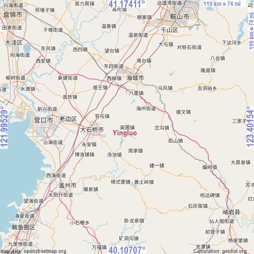
Yingluo GPS coordinates[2]
40° 38' 33.792" North, 122° 41' 54.276" East
| Map corner | latitude | longitude |
|---|---|---|
| Upper-left | 41.17411°, | 121.99529° |
| Center: | 40.64272°, | 122.69841° |
| Lower-right: | 40.10707°, | 123.40154° |
| Map W x H: | 118.6×118.6 km | = 73.7×73.7mi |
| max Lat: | 53.31946° ⇑11.6% North |
| Yingluo: | 40.64272° |
| min Lat: | ⇓88.4% South 18.22056° |
| min Long | Yingluo | max Long |
| 75.07348° | 122.69841° | 134.28917° |
| W 92.3%⇐ | ⇒7.7% E |
Elevation
Elevation of Yingluo is 111 m = 364 ft, and this is 373.8 m = 1226 ft below average elevation for this country.
| Max E: |
5622 m = 18445 ft | 58.1% |
| Avg. | 484.8 m = 1591 ft | |
| Yingluo | 111 m = 364 ft | |
Min E: |
-3 m = -10 ft | 41.9% |
See also: China elevation on elevation.city.
Geographical zone
Yingluo is located in North temperate zone (between Tropic of Cancer and the Arctic Circle). Distance of this Northern Tropic circle is 1913.1 km =1188.7 mi to South.| Distance of | km | miles | from Yingluo |
|---|---|---|---|
| North Pole | 5488 | 3410.1 | to North |
| Arctic Circle | 2882.1 | 1790.9 | to North |
| Tropic Cancer | 1913.1 | 1188.7 | to South |
| Equator | 4519 | 2808 | to South |


Nearby cities:
15 places around Yingluo: (largest is in red/bold)
• Bali
16.9 km =10.5 mi,  16°
16°
• Chagou
14 km =8.7 mi,  101°
101°
• Dashiqiao
16.5 km =10.3 mi,  267°
267°
• Gangdu
15.7 km =9.8 mi, 268°
• Guantun
12.7 km =7.9 mi,  292°
292°
• Huzhuang
15.6 km =9.7 mi,  301°
301°
• Jinqiao
18.3 km =11.4 mi, 266°
• Maoqi
16.7 km =10.4 mi,  358°
358°
• Pailou
14.1 km =8.8 mi,  44°
44°
• Shiqiao
17 km =10.6 mi, 267°
• Tangchi
14 km =8.7 mi,  206°
206°
• Weiziyu
18 km =11.2 mi,  172°
172°
• Ximu
18.7 km =11.6 mi,  70°
70°
• Yong’an
19.2 km =11.9 mi,  245°
245°
• Zhoujia
11.6 km =7.2 mi,  160°
160°
Sources, notices
• [Note1] Compared only with cities in China existing in our database
• [Src1] Map data: © OpenStreetMap contributors (CC-BY-SA)
• [Src2] Other city data from geonames.org with taken over terms of usage.
• [Src3] Geographical zone / Annual Mean Temperature by Robert A. Rohde @ Wikipedia
