Huzhuang geodata
Huzhuang (Liaoning) is a seat of a fourth-order administrative division; located in China in Asia/Shanghai (GMT+8) time zone. In our database, there are 1268 cities with bigger population. Compared to other cities in China, 88.5% of cities are located further ↓South; 92.2% of cities are located further ←West and 82.1% of cities have higher elevation than Huzhuang. Note1


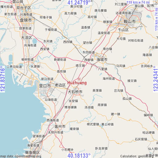
Huzhuang GPS coordinates[2]
40° 42' 59.004" North, 122° 32' 25.008" East
| Map corner | latitude | longitude |
|---|---|---|
| Upper-left | 41.24719°, | 121.83716° |
| Center: | 40.71639°, | 122.54028° |
| Lower-right: | 40.18133°, | 123.24341° |
| Map W x H: | 118.5×118.5 km | = 73.6×73.6mi |
| max Lat: | 53.31946° ⇑11.5% North |
| Huzhuang: | 40.71639° |
| min Lat: | ⇓88.5% South 18.22056° |
| min Long | Huzhuang | max Long |
| 75.07348° | 122.54028° | 134.28917° |
| W 92.2%⇐ | ⇒7.8% E |
Elevation
Elevation of Huzhuang is 22 m = 72 ft, and this is 462.8 m = 1518 ft below average elevation for this country.
| Max E: |
5622 m = 18445 ft | 82.1% |
| Avg. | 484.8 m = 1591 ft | |
| Huzhuang | 22 m = 72 ft | |
Min E: |
-3 m = -10 ft | 17.9% |
See also: China elevation on elevation.city.
Geographical zone
Huzhuang is located in North temperate zone (between Tropic of Cancer and the Arctic Circle). Distance of this Northern Tropic circle is 1921.3 km =1193.8 mi to South.| Distance of | km | miles | from Huzhuang |
|---|---|---|---|
| North Pole | 5479.8 | 3405 | to North |
| Arctic Circle | 2873.9 | 1785.8 | to North |
| Tropic Cancer | 1921.3 | 1193.8 | to South |
| Equator | 4527.2 | 2813.1 | to South |


Nearby cities:
15 places around Huzhuang: (largest is in red/bold)
• Biancheng
15.6 km =9.7 mi,  254°
254°
• Chengdong
13.2 km =8.2 mi,  240°
240°
• Dashiqiao
9.4 km =5.8 mi,  199°
199°
• Gangdu
8.9 km =5.5 mi, 195°
• Ganwang
10.8 km =6.7 mi,  5°
5°
• Gaokan
15.4 km =9.6 mi,  294°
294°
• Guantun
3.7 km =2.3 mi,  153°
153°
• Jinqiao
10.5 km =6.5 mi,  207°
207°
• Liushu
15.7 km =9.8 mi,  222°
222°
• Maoqi
15.5 km =9.6 mi,  56°
56°
• Qianliu
16 km =9.9 mi,  29°
29°
• Shiqiao
9.6 km =6 mi, 201°
• Xiliu
16.3 km =10.1 mi, 25°
• Yingluo
15.6 km =9.7 mi,  121°
121°
• Yong’an
16.7 km =10.4 mi,  194°
194°
Sources, notices
• [Note1] Compared only with cities in China existing in our database
• [Src1] Map data: © OpenStreetMap contributors (CC-BY-SA)
• [Src2] Other city data from geonames.org with taken over terms of usage.
• [Src3] Geographical zone / Annual Mean Temperature by Robert A. Rohde @ Wikipedia
