Chagou geodata
Chagou (Liaoning) is a seat of a fourth-order administrative division; located in China in Asia/Shanghai (GMT+8) time zone. In our database, there are 1268 cities with bigger population. Compared to other cities in China, 88.3% of cities are located further ↓South; 92.6% of cities are located further ←West and 57.9% of cities have higher elevation than Chagou. Note1


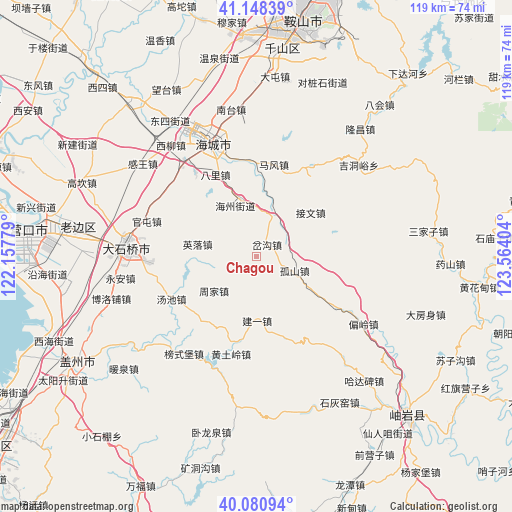
Chagou GPS coordinates[2]
40° 37' 0.48" North, 122° 51' 39.276" East
| Map corner | latitude | longitude |
|---|---|---|
| Upper-left | 41.14839°, | 122.15779° |
| Center: | 40.6168°, | 122.86091° |
| Lower-right: | 40.08094°, | 123.56404° |
| Map W x H: | 118.7×118.7 km | = 73.8×73.8mi |
| max Lat: | 53.31946° ⇑11.7% North |
| Chagou: | 40.6168° |
| min Lat: | ⇓88.3% South 18.22056° |
| min Long | Chagou | max Long |
| 75.07348° | 122.86091° | 134.28917° |
| W 92.6%⇐ | ⇒7.4% E |
Elevation
Elevation of Chagou is 112 m = 367 ft, and this is 372.8 m = 1223 ft below average elevation for this country.
| Max E: |
5622 m = 18445 ft | 57.9% |
| Avg. | 484.8 m = 1591 ft | |
| Chagou | 112 m = 367 ft | |
Min E: |
-3 m = -10 ft | 42.1% |
See also: China elevation on elevation.city.
Geographical zone
Chagou is located in North temperate zone (between Tropic of Cancer and the Arctic Circle). Distance of this Northern Tropic circle is 1910.2 km =1186.9 mi to South.| Distance of | km | miles | from Chagou |
|---|---|---|---|
| North Pole | 5490.9 | 3411.9 | to North |
| Arctic Circle | 2885 | 1792.7 | to North |
| Tropic Cancer | 1910.2 | 1186.9 | to South |
| Equator | 4516.2 | 2806.2 | to South |


Nearby cities:
15 places around Chagou: (largest is in red/bold)
• Bali
21.1 km =13.1 mi,  334°
334°
• Gushan
9.5 km =5.9 mi,  111°
111°
• Huangtuling
23.4 km =14.5 mi,  194°
194°
• Jianyi
14.9 km =9.3 mi,  178°
178°
• Jiewen
16.1 km =10 mi,  50°
50°
• Lüwang
24.2 km =15 mi, 177°
• Mafeng
21.8 km =13.5 mi,  10°
10°
• Maoqi
24.1 km =15 mi,  324°
324°
• Pailou
13.4 km =8.3 mi,  343°
343°
• Tangchi
22.3 km =13.9 mi,  244°
244°
• Weiziyu
18.8 km =11.7 mi,  217°
217°
• Xiangtang
25.2 km =15.7 mi, 342°
• Ximu
10 km =6.2 mi,  23°
23°
• Yingluo
14 km =8.7 mi,  281°
281°
• Zhoujia
12.7 km =7.9 mi,  230°
230°
Sources, notices
• [Note1] Compared only with cities in China existing in our database
• [Src1] Map data: © OpenStreetMap contributors (CC-BY-SA)
• [Src2] Other city data from geonames.org with taken over terms of usage.
• [Src3] Geographical zone / Annual Mean Temperature by Robert A. Rohde @ Wikipedia
