Wumahe geodata
Wumahe (Heilongjiang) is a seat of a third-order administrative division; located in China in Asia/Shanghai (GMT+8) time zone. In our database, there are 1268 cities with bigger population. Compared to other cities in China, 98.2% of cities are located further ↓South; 98.3% of cities are located further ←West and 58.7% of cities have lower elevation than Wumahe. Note1


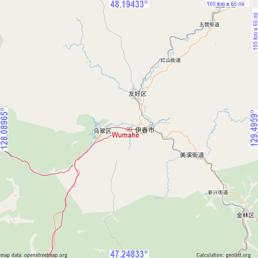
Wumahe GPS coordinates[2]
47° 43' 24.528" North, 128° 47' 33.972" East
| Map corner | latitude | longitude |
|---|---|---|
| Upper-left | 48.19433°, | 128.08965° |
| Center: | 47.72348°, | 128.79277° |
| Lower-right: | 47.24833°, | 129.4959° |
| Map W x H: | 105.2×105.2 km | = 65.4×65.4mi |
| max Lat: | 53.31946° ⇑1.8% North |
| Wumahe: | 47.72348° |
| min Lat: | ⇓98.2% South 18.22056° |
| min Long | Wumahe | max Long |
| 75.07348° | 128.79277° | 134.28917° |
| W 98.3%⇐ | ⇒1.7% E |
Elevation
Elevation of Wumahe is 244 m = 801 ft, and this is 240.8 m = 790 ft below average elevation for this country.
| Max E: |
5622 m = 18445 ft | 41.3% |
| Avg. | 484.8 m = 1591 ft | |
| Wumahe | 244 m = 801 ft | |
Min E: |
-3 m = -10 ft | 58.7% |
See also: China elevation on elevation.city.
Geographical zone
Wumahe is located in North temperate zone (between Tropic of Cancer and the Arctic Circle). Distance of this North polar circle is 2094.8 km =1301.6 mi to North.| Distance of | km | miles | from Wumahe |
|---|---|---|---|
| North Pole | 4700.7 | 2920.9 | to North |
| Arctic Circle | 2094.8 | 1301.6 | to North |
| Tropic Cancer | 2700.4 | 1678 | to South |
| Equator | 5306.4 | 3297.2 | to South |


Nearby cities:
15 places around Wumahe: (largest is in red/bold)
• Chenming
98 km =60.9 mi,  147°
147°
• Dailing
79.6 km =49.5 mi,  167°
167°
• Fendou
59.1 km =36.7 mi,  126°
126°
• Hongshan
32.9 km =20.4 mi,  31°
31°
• Langxiang
86.2 km =53.6 mi,  176°
176°
• Lianhe
74.9 km =46.5 mi, 151°
• Meixi
27.3 km =17 mi,  111°
111°
• Shenshu
91.4 km =56.8 mi,  197°
197°
• Shuguang
8.9 km =5.5 mi,  270°
270°
• Xilin
47.2 km =29.3 mi, 125°
• Xinqing
82.9 km =51.5 mi,  40°
40°
• Xuri
8 km =5 mi,  87°
87°
• Yichun
6.2 km =3.9 mi, 92°
• Yingchun
72.4 km =45 mi, 152°
• Youhao
14.8 km =9.2 mi,  12°
12°
Sources, notices
• [Note1] Compared only with cities in China existing in our database
• [Src1] Map data: © OpenStreetMap contributors (CC-BY-SA)
• [Src2] Other city data from geonames.org with taken over terms of usage.
• [Src3] Geographical zone / Annual Mean Temperature by Robert A. Rohde @ Wikipedia
