Wenquan geodata
Wenquan (Beijing) is a seat of a fourth-order administrative division; located in China in Asia/Shanghai (GMT+8) time zone. In our database, there are 1268 cities with bigger population. Compared to other cities in China, 86.5% of cities are located further ↓South; 61.1% of cities are located further ←West and 69.2% of cities have higher elevation than Wenquan. Note1


Wenquan GPS coordinates[2]
40° 2' 31.344" North, 116° 11' 26.916" East
| Map corner | latitude | longitude |
|---|---|---|
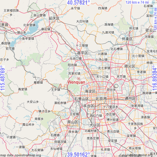
| Upper-left | 40.57821°, | 115.48769° |
| Center: | 40.04204°, | 116.19081° |
| Lower-right: | 39.50162°, | 116.89394° |
| Map W x H: | 119.7×119.7 km | = 74.4×74.4mi |
| max Lat: | 53.31946° ⇑13.5% North |
| Wenquan: | 40.04204° |
| min Lat: | ⇓86.5% South 18.22056° |
| min Long | Wenquan | max Long |
| 75.07348° | 116.19081° | 134.28917° |
| W 61.1%⇐ | ⇒38.9% E |
Elevation
Elevation of Wenquan is 55 m = 180 ft, and this is 429.8 m = 1410 ft below average elevation for this country.
| Max E: |
5622 m = 18445 ft | 69.2% |
| Avg. | 484.8 m = 1591 ft | |
| Wenquan | 55 m = 180 ft | |
Min E: |
-3 m = -10 ft | 30.8% |
See also: China elevation on elevation.city.
Geographical zone
Wenquan is located in North temperate zone (between Tropic of Cancer and the Arctic Circle). Distance of this Northern Tropic circle is 1846.3 km =1147.2 mi to South.| Distance of | km | miles | from Wenquan |
|---|---|---|---|
| North Pole | 5554.8 | 3451.6 | to North |
| Arctic Circle | 2948.9 | 1832.4 | to North |
| Tropic Cancer | 1846.3 | 1147.2 | to South |
| Equator | 4452.3 | 2766.5 | to South |


Nearby cities:
15 places around Wenquan: (largest is in red/bold)
• Chengzi
13.3 km =8.3 mi,  220°
220°
• Dayu
14.1 km =8.8 mi,  214°
214°
• Guangning
13.6 km =8.5 mi,  199°
199°
• Haidian
10.1 km =6.3 mi,  124°
124°
• Huilongguan
12.9 km =8 mi,  72°
72°
• Junzhuang
9.5 km =5.9 mi,  241°
241°
• Mentougou
14.2 km =8.8 mi, 215°
• Miaofengshan
14.3 km =8.9 mi, 238°
• Qinghe
12.2 km =7.6 mi,  96°
96°
• Shahe
10.8 km =6.7 mi,  33°
33°
• Sijiqing
12 km =7.5 mi,  147°
147°
• Sujiatuo
4.7 km =2.9 mi,  324°
324°
• Xiangshan
5.5 km =3.4 mi,  170°
170°
• Xibeiwang
5.4 km =3.4 mi,  85°
85°
• Yangfang
12 km =7.5 mi,  333°
333°
Sources, notices
• [Note1] Compared only with cities in China existing in our database
• [Src1] Map data: © OpenStreetMap contributors (CC-BY-SA)
• [Src2] Other city data from geonames.org with taken over terms of usage.
• [Src3] Geographical zone / Annual Mean Temperature by Robert A. Rohde @ Wikipedia
