Guangning geodata
Guangning (Beijing) is a seat of a fourth-order administrative division; located in China in Asia/Shanghai (GMT+8) time zone. In our database, there are 1268 cities with bigger population. Compared to other cities in China, 86.2% of cities are located further ↓South; 60.9% of cities are located further ←West and 59.9% of cities have higher elevation than Guangning. Note1


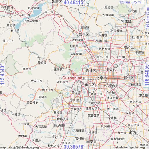
Guangning GPS coordinates[2]
39° 55' 37.488" North, 116° 8' 14.712" East
| Map corner | latitude | longitude |
|---|---|---|
| Upper-left | 40.46415°, | 115.4343° |
| Center: | 39.92708°, | 116.13742° |
| Lower-right: | 39.38576°, | 116.84055° |
| Map W x H: | 119.9×119.9 km | = 74.5×74.5mi |
| max Lat: | 53.31946° ⇑13.8% North |
| Guangning: | 39.92708° |
| min Lat: | ⇓86.2% South 18.22056° |
| min Long | Guangning | max Long |
| 75.07348° | 116.13742° | 134.28917° |
| W 60.9%⇐ | ⇒39.1% E |
Elevation
Elevation of Guangning is 99 m = 325 ft, and this is 385.8 m = 1266 ft below average elevation for this country.
| Max E: |
5622 m = 18445 ft | 59.9% |
| Avg. | 484.8 m = 1591 ft | |
| Guangning | 99 m = 325 ft | |
Min E: |
-3 m = -10 ft | 40.1% |
See also: China elevation on elevation.city.
Geographical zone
Guangning is located in North temperate zone (between Tropic of Cancer and the Arctic Circle). Distance of this Northern Tropic circle is 1833.6 km =1139.3 mi to South.| Distance of | km | miles | from Guangning |
|---|---|---|---|
| North Pole | 5567.6 | 3459.5 | to North |
| Arctic Circle | 2961.7 | 1840.3 | to North |
| Tropic Cancer | 1833.6 | 1139.3 | to South |
| Equator | 4439.5 | 2758.6 | to South |


Nearby cities:
15 places around Guangning: (largest is in red/bold)
• Babaoshan
8.5 km =5.3 mi,  110°
110°
• Chengzi
4.9 km =3 mi,  302°
302°
• Dayu
3.7 km =2.3 mi,  288°
288°
• Fengtai
14.5 km =9 mi,  127°
127°
• Junzhuang
9.1 km =5.7 mi,  335°
335°
• Lugouqiao
13.6 km =8.5 mi,  118°
118°
• Lugu
7.8 km =4.8 mi, 115°
• Mentougou
4 km =2.5 mi, 288°
• Miaofengshan
9.2 km =5.7 mi, 304°
• Sijiqing
11.2 km =7 mi,  76°
76°
• Tanzhesi
11.1 km =6.9 mi,  236°
236°
• Wangping
14 km =8.7 mi, 288°
• Wangzuo
13.4 km =8.3 mi,  173°
173°
• Wenquan
13.6 km =8.5 mi,  19°
19°
• Xiangshan
9.1 km =5.7 mi,  36°
36°
Sources, notices
• [Note1] Compared only with cities in China existing in our database
• [Src1] Map data: © OpenStreetMap contributors (CC-BY-SA)
• [Src2] Other city data from geonames.org with taken over terms of usage.
• [Src3] Geographical zone / Annual Mean Temperature by Robert A. Rohde @ Wikipedia
