Shahe geodata
Shahe (Beijing) is a seat of a fourth-order administrative division; located in China in Asia/Shanghai (GMT+8) time zone. In our database, there are 1268 cities with bigger population. Compared to other cities in China, 86.8% of cities are located further ↓South; 61.5% of cities are located further ←West and 72.3% of cities have higher elevation than Shahe. Note1


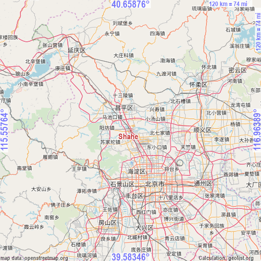
Shahe GPS coordinates[2]
40° 7' 23.664" North, 116° 15' 38.736" East
| Map corner | latitude | longitude |
|---|---|---|
| Upper-left | 40.65876°, | 115.55764° |
| Center: | 40.12324°, | 116.26076° |
| Lower-right: | 39.58346°, | 116.96389° |
| Map W x H: | 119.6×119.6 km | = 74.3×74.3mi |
| max Lat: | 53.31946° ⇑13.2% North |
| Shahe: | 40.12324° |
| min Lat: | ⇓86.8% South 18.22056° |
| min Long | Shahe | max Long |
| 75.07348° | 116.26076° | 134.28917° |
| W 61.5%⇐ | ⇒38.5% E |
Elevation
Elevation of Shahe is 44 m = 144 ft, and this is 440.8 m = 1446 ft below average elevation for this country.
| Max E: |
5622 m = 18445 ft | 72.3% |
| Avg. | 484.8 m = 1591 ft | |
| Shahe | 44 m = 144 ft | |
Min E: |
-3 m = -10 ft | 27.7% |
See also: China elevation on elevation.city.
Geographical zone
Shahe is located in North temperate zone (between Tropic of Cancer and the Arctic Circle). Distance of this Northern Tropic circle is 1855.4 km =1152.9 mi to South.| Distance of | km | miles | from Shahe |
|---|---|---|---|
| North Pole | 5545.8 | 3446 | to North |
| Arctic Circle | 2939.9 | 1826.8 | to North |
| Tropic Cancer | 1855.4 | 1152.9 | to South |
| Equator | 4461.3 | 2772.1 | to South |


Nearby cities:
15 places around Shahe: (largest is in red/bold)
• Beiqijia
13.3 km =8.3 mi,  92°
92°
• Changping
10.6 km =6.6 mi,  347°
347°
• Chengbei
11.2 km =7 mi, 353°
• Chengnan
9.8 km =6.1 mi,  344°
344°
• Cuicun
13.1 km =8.1 mi,  36°
36°
• Dongxiaokou
14.2 km =8.8 mi,  121°
121°
• Huilongguan
8.1 km =5 mi,  128°
128°
• Machikou
10.7 km =6.6 mi,  307°
307°
• Nanshao
9.3 km =5.8 mi,  9°
9°
• Qinghe
12.1 km =7.5 mi,  149°
149°
• Sujiatuo
10.1 km =6.3 mi,  239°
239°
• Wenquan
10.8 km =6.7 mi,  213°
213°
• Xiaotangshan
12.1 km =7.5 mi,  60°
60°
• Xibeiwang
8.6 km =5.3 mi,  183°
183°
• Yangfang
11.4 km =7.1 mi,  278°
278°
Sources, notices
• [Note1] Compared only with cities in China existing in our database
• [Src1] Map data: © OpenStreetMap contributors (CC-BY-SA)
• [Src2] Other city data from geonames.org with taken over terms of usage.
• [Src3] Geographical zone / Annual Mean Temperature by Robert A. Rohde @ Wikipedia
