Dayu geodata
Dayu (Beijing) is a seat of a third-order administrative division; located in China in Asia/Shanghai (GMT+8) time zone. In our database, there are 1268 cities with bigger population. Compared to other cities in China, 86.2% of cities are located further ↓South; 60.6% of cities are located further ←West and 58.9% of cities have higher elevation than Dayu. Note1


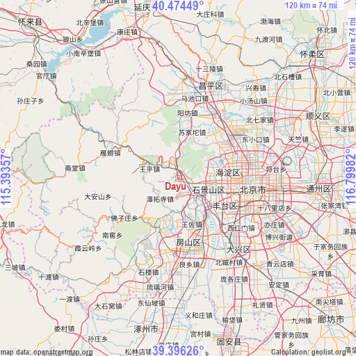
Dayu GPS coordinates[2]
39° 56' 15" North, 116° 5' 48.084" East
| Map corner | latitude | longitude |
|---|---|---|
| Upper-left | 40.47449°, | 115.39357° |
| Center: | 39.9375°, | 116.09669° |
| Lower-right: | 39.39626°, | 116.79982° |
| Map W x H: | 119.9×119.9 km | = 74.5×74.5mi |
| max Lat: | 53.31946° ⇑13.8% North |
| Dayu: | 39.9375° |
| min Lat: | ⇓86.2% South 18.22056° |
| min Long | Dayu | max Long |
| 75.07348° | 116.09669° | 134.28917° |
| W 60.6%⇐ | ⇒39.4% E |
Elevation
Elevation of Dayu is 105 m = 344 ft, and this is 379.8 m = 1246 ft below average elevation for this country.
| Max E: |
5622 m = 18445 ft | 58.9% |
| Avg. | 484.8 m = 1591 ft | |
| Dayu | 105 m = 344 ft | |
Min E: |
-3 m = -10 ft | 41.1% |
See also: China elevation on elevation.city.
Geographical zone
Dayu is located in North temperate zone (between Tropic of Cancer and the Arctic Circle). Distance of this Northern Tropic circle is 1834.7 km =1140 mi to South.| Distance of | km | miles | from Dayu |
|---|---|---|---|
| North Pole | 5566.4 | 3458.8 | to North |
| Arctic Circle | 2960.5 | 1839.6 | to North |
| Tropic Cancer | 1834.7 | 1140 | to South |
| Equator | 4440.6 | 2759.3 | to South |


Nearby cities:
15 places around Dayu: (largest is in red/bold)
• Babaoshan
12.1 km =7.5 mi,  109°
109°
• Chengzi
1.6 km =1 mi,  336°
336°
• Guangning
3.7 km =2.3 mi, 108°
• Junzhuang
7.1 km =4.4 mi,  357°
357°
• Lugouqiao
17.2 km =10.7 mi,  116°
116°
• Lugu
11.5 km =7.1 mi, 113°
• Mentougou
0.3 km =0.2 mi,  283°
283°
• Miaofengshan
5.8 km =3.6 mi,  314°
314°
• Sijiqing
14.5 km =9 mi,  84°
84°
• Sujiatuo
16.4 km =10.2 mi,  18°
18°
• Tanzhesi
9.3 km =5.8 mi,  218°
218°
• Wangping
10.4 km =6.5 mi,  288°
288°
• Wangzuo
15.3 km =9.5 mi,  160°
160°
• Wenquan
14.1 km =8.8 mi,  34°
34°
• Xiangshan
10.8 km =6.7 mi,  55°
55°
Sources, notices
• [Note1] Compared only with cities in China existing in our database
• [Src1] Map data: © OpenStreetMap contributors (CC-BY-SA)
• [Src2] Other city data from geonames.org with taken over terms of usage.
• [Src3] Geographical zone / Annual Mean Temperature by Robert A. Rohde @ Wikipedia
