Wangqing geodata
Wangqing (Jilin) is a seat of a third-order administrative division; located in China in Asia/Shanghai (GMT+8) time zone. With population of 88,732 people, there are 482 cities with bigger population in this country. Compared to other cities in China, 92.2% of cities are located further ↓South; 99% of cities are located further ←West and 57.9% of cities have lower elevation than Wangqing. Note1


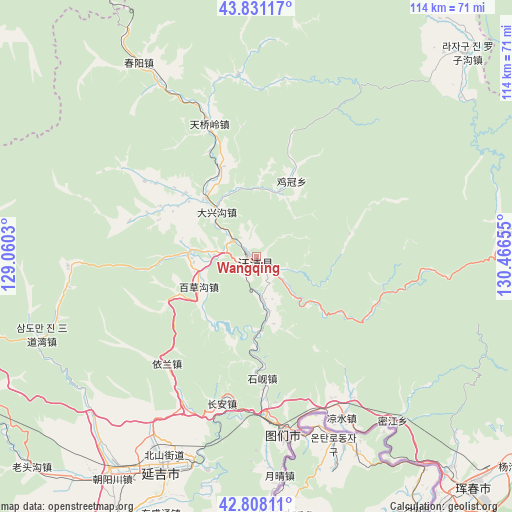
Wangqing GPS coordinates[2]
43° 19' 18.444" North, 129° 45' 48.312" East
| Map corner | latitude | longitude |
|---|---|---|
| Upper-left | 43.83117°, | 129.0603° |
| Center: | 43.32179°, | 129.76342° |
| Lower-right: | 42.80811°, | 130.46655° |
| Map W x H: | 113.8×113.8 km | = 70.7×70.7mi |
| max Lat: | 53.31946° ⇑7.8% North |
| Wangqing: | 43.32179° |
| min Lat: | ⇓92.2% South 18.22056° |
| min Long | Wangqing | max Long |
| 75.07348° | 129.76342° | 134.28917° |
| W 99%⇐ | ⇒1% E |
Elevation
Elevation of Wangqing is 235 m = 771 ft, and this is 249.8 m = 820 ft below average elevation for this country.
| Max E: |
5622 m = 18445 ft | 42.1% |
| Avg. | 484.8 m = 1591 ft | |
| Wangqing | 235 m = 771 ft | |
Min E: |
-3 m = -10 ft | 57.9% |
See also: Wangqing elevation on elevation.city.
Geographical zone
Wangqing is located in North temperate zone (between Tropic of Cancer and the Arctic Circle). Distance of this Northern Tropic circle is 2211 km =1373.9 mi to South.| Distance of | km | miles | from Wangqing |
|---|---|---|---|
| North Pole | 5190.1 | 3225 | to North |
| Arctic Circle | 2584.2 | 1605.7 | to North |
| Tropic Cancer | 2211 | 1373.9 | to South |
| Equator | 4816.9 | 2993.1 | to South |


Nearby cities:
15 places around Wangqing: (largest is in red/bold)
• Baicaogou
14.4 km =8.9 mi,  244°
244°
• Chang’an
33.6 km =20.9 mi,  193°
193°
• Chunyang
50.9 km =31.6 mi,  328°
328°
• Daxinggou
12.6 km =7.8 mi,  319°
319°
• Dongguang
4.9 km =3 mi,  133°
133°
• Hamatang
24.1 km =15 mi,  297°
297°
• Jiguan
18.7 km =11.6 mi,  24°
24°
• Jiulong
31.1 km =19.3 mi,  219°
219°
• Mijiang
47.4 km =29.5 mi,  139°
139°
• Sandaowan
50.8 km =31.6 mi,  249°
249°
• Shixian
26.5 km =16.5 mi,  179°
179°
• Tianqiaoling
31.7 km =19.7 mi,  340°
340°
• Tumen
40.1 km =24.9 mi,  170°
170°
• Xiaoying
49.6 km =30.8 mi,  203°
203°
• Yanji
50.5 km =31.4 mi, 204°
In other languages:
- In Russian: Ванцине
- In Chinese: Wang-ch’ing, Wang-ch’ing-chen, Wang-ch’ing-hsien, Ta-tu-ch’uan, 汪清
Sources, notices
• [Note1] Compared only with cities in China existing in our database
• [Src1] Map data: © OpenStreetMap contributors (CC-BY-SA)
• [Src2] Other city data from geonames.org with taken over terms of usage.
• [Src3] Geographical zone / Annual Mean Temperature by Robert A. Rohde @ Wikipedia
