Chang’an geodata
Chang’an (Jilin) is a seat of a fourth-order administrative division; located in China in Asia/Shanghai (GMT+8) time zone. In our database, there are 1268 cities with bigger population. Compared to other cities in China, 92% of cities are located further ↓South; 98.9% of cities are located further ←West and 53.5% of cities have higher elevation than Chang’an. Note1


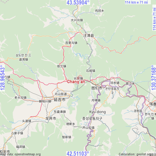
Chang’an GPS coordinates[2]
43° 1' 37.884" North, 129° 40' 6.78" East
| Map corner | latitude | longitude |
|---|---|---|
| Upper-left | 43.53904°, | 128.96543° |
| Center: | 43.02719°, | 129.66855° |
| Lower-right: | 42.51103°, | 130.37168° |
| Map W x H: | 114.3×114.3 km | = 71×71mi |
| max Lat: | 53.31946° ⇑8% North |
| Chang’an: | 43.02719° |
| min Lat: | ⇓92% South 18.22056° |
| min Long | Chang’an | max Long |
| 75.07348° | 129.66855° | 134.28917° |
| W 98.9%⇐ | ⇒1.1% E |
Elevation
Elevation of Chang’an is 140 m = 459 ft, and this is 344.8 m = 1131 ft below average elevation for this country.
| Max E: |
5622 m = 18445 ft | 53.5% |
| Avg. | 484.8 m = 1591 ft | |
| Chang’an | 140 m = 459 ft | |
Min E: |
-3 m = -10 ft | 46.5% |
See also: China elevation on elevation.city.
Geographical zone
Chang’an is located in North temperate zone (between Tropic of Cancer and the Arctic Circle). Distance of this Northern Tropic circle is 2178.3 km =1353.5 mi to South.| Distance of | km | miles | from Chang’an |
|---|---|---|---|
| North Pole | 5222.9 | 3245.4 | to North |
| Arctic Circle | 2617 | 1626.1 | to North |
| Tropic Cancer | 2178.3 | 1353.5 | to South |
| Equator | 4784.2 | 2972.8 | to South |


Nearby cities:
15 places around Chang’an: (largest is in red/bold)
• Baicaogou
27 km =16.8 mi,  348°
348°
• Chaoyangchuan
29.9 km =18.6 mi,  236°
236°
• Chongmin
33.7 km =20.9 mi,  189°
189°
• Dongguang
31.4 km =19.5 mi,  20°
20°
• Dongshengyong
27.9 km =17.3 mi,  209°
209°
• Jiulong
15.2 km =9.4 mi,  305°
305°
• Kaishantun
36.9 km =22.9 mi,  168°
168°
• Longjing
34.8 km =21.6 mi,  215°
215°
• Mijiang
38.6 km =24 mi,  95°
95°
• Shixian
10.1 km =6.3 mi,  51°
51°
• Tongfosi
38 km =23.6 mi,  245°
245°
• Tumen
15.7 km =9.8 mi,  115°
115°
• Wangqing
33.6 km =20.9 mi,  13°
13°
• Xiaoying
17.6 km =10.9 mi, 223°
• Yanji
18.7 km =11.6 mi, 224°
Sources, notices
• [Note1] Compared only with cities in China existing in our database
• [Src1] Map data: © OpenStreetMap contributors (CC-BY-SA)
• [Src2] Other city data from geonames.org with taken over terms of usage.
• [Src3] Geographical zone / Annual Mean Temperature by Robert A. Rohde @ Wikipedia
