Wangjiang geodata
Wangjiang (Heilongjiang) is a seat of a fourth-order administrative division; located in China in Asia/Shanghai (GMT+8) time zone. In our database, there are 1268 cities with bigger population. Compared to other cities in China, 96.6% of cities are located further ↓South; 99.2% of cities are located further ←West and 63.1% of cities have higher elevation than Wangjiang. Note1


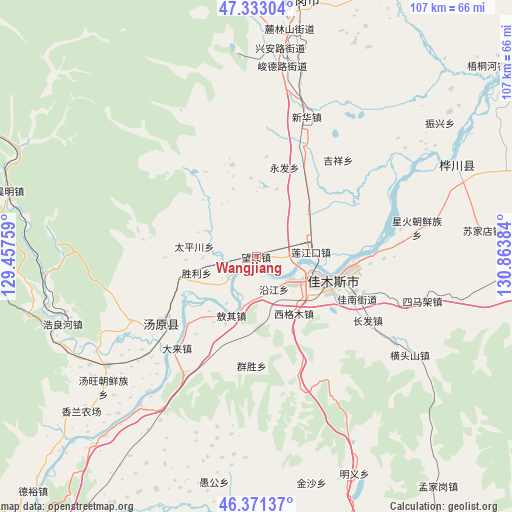
Wangjiang GPS coordinates[2]
46° 51' 15.696" North, 130° 9' 38.556" East
| Map corner | latitude | longitude |
|---|---|---|
| Upper-left | 47.33304°, | 129.45759° |
| Center: | 46.85436°, | 130.16071° |
| Lower-right: | 46.37137°, | 130.86384° |
| Map W x H: | 106.9×106.9 km | = 66.4×66.4mi |
| max Lat: | 53.31946° ⇑3.4% North |
| Wangjiang: | 46.85436° |
| min Lat: | ⇓96.6% South 18.22056° |
| min Long | Wangjiang | max Long |
| 75.07348° | 130.16071° | 134.28917° |
| W 99.2%⇐ | ⇒0.8% E |
Elevation
Elevation of Wangjiang is 82 m = 269 ft, and this is 402.8 m = 1322 ft below average elevation for this country.
| Max E: |
5622 m = 18445 ft | 63.1% |
| Avg. | 484.8 m = 1591 ft | |
| Wangjiang | 82 m = 269 ft | |
Min E: |
-3 m = -10 ft | 36.9% |
See also: China elevation on elevation.city.
Geographical zone
Wangjiang is located in North temperate zone (between Tropic of Cancer and the Arctic Circle). Distance of this North polar circle is 2191.5 km =1361.7 mi to North.| Distance of | km | miles | from Wangjiang |
|---|---|---|---|
| North Pole | 4797.3 | 2980.9 | to North |
| Arctic Circle | 2191.5 | 1361.7 | to North |
| Tropic Cancer | 2603.8 | 1617.9 | to South |
| Equator | 5209.7 | 3237.2 | to South |


Nearby cities:
15 places around Wangjiang: (largest is in red/bold)
• Aoqi
13.4 km =8.3 mi,  202°
202°
• Changqing
11.5 km =7.1 mi,  120°
120°
• Jiamusi
13.3 km =8.3 mi, 117°
• Jianguo
18.4 km =11.4 mi,  102°
102°
• Lianjiangkou
11.2 km =7 mi,  85°
85°
• Ping’an
12.3 km =7.6 mi,  78°
78°
• Qiaonan
16 km =9.9 mi,  110°
110°
• Shengli
12.8 km =8 mi,  253°
253°
• Songjiang
20.7 km =12.9 mi, 96°
• Taipingchuan
13 km =8.1 mi,  278°
278°
• Xigemu
14.3 km =8.9 mi,  146°
146°
• Yanjiang
7.9 km =4.9 mi, 151°
• Yongfa
19.4 km =12.1 mi,  17°
17°
• Youyi
13.3 km =8.3 mi, 114°
• Zhanqian
17.4 km =10.8 mi, 110°
Sources, notices
• [Note1] Compared only with cities in China existing in our database
• [Src1] Map data: © OpenStreetMap contributors (CC-BY-SA)
• [Src2] Other city data from geonames.org with taken over terms of usage.
• [Src3] Geographical zone / Annual Mean Temperature by Robert A. Rohde @ Wikipedia
