Songjiang geodata
Songjiang (Heilongjiang) is a seat of a fourth-order administrative division; located in China in Asia/Shanghai (GMT+8) time zone. In our database, there are 1268 cities with bigger population. Compared to other cities in China, 96.6% of cities are located further ↓South; 99.5% of cities are located further ←West and 63.5% of cities have higher elevation than Songjiang. Note1


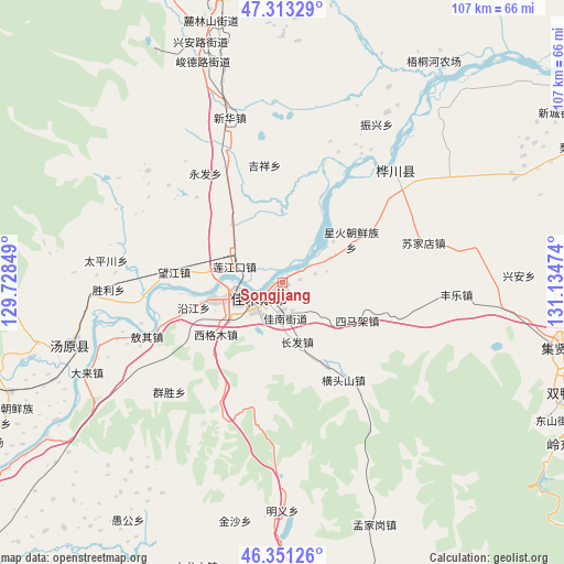
Songjiang GPS coordinates[2]
46° 50' 3.948" North, 130° 25' 53.796" East
| Map corner | latitude | longitude |
|---|---|---|
| Upper-left | 47.31329°, | 129.72849° |
| Center: | 46.83443°, | 130.43161° |
| Lower-right: | 46.35126°, | 131.13474° |
| Map W x H: | 107×107 km | = 66.5×66.5mi |
| max Lat: | 53.31946° ⇑3.4% North |
| Songjiang: | 46.83443° |
| min Lat: | ⇓96.6% South 18.22056° |
| min Long | Songjiang | max Long |
| 75.07348° | 130.43161° | 134.28917° |
| W 99.5%⇐ | ⇒0.5% E |
Elevation
Elevation of Songjiang is 80 m = 262 ft, and this is 404.8 m = 1328 ft below average elevation for this country.
| Max E: |
5622 m = 18445 ft | 63.5% |
| Avg. | 484.8 m = 1591 ft | |
| Songjiang | 80 m = 262 ft | |
Min E: |
-3 m = -10 ft | 36.5% |
See also: China elevation on elevation.city.
Geographical zone
Songjiang is located in North temperate zone (between Tropic of Cancer and the Arctic Circle). Distance of this North polar circle is 2193.7 km =1363.1 mi to North.| Distance of | km | miles | from Songjiang |
|---|---|---|---|
| North Pole | 4799.6 | 2982.3 | to North |
| Arctic Circle | 2193.7 | 1363.1 | to North |
| Tropic Cancer | 2601.6 | 1616.6 | to South |
| Equator | 5207.5 | 3235.8 | to South |


Nearby cities:
15 places around Songjiang: (largest is in red/bold)
• Changfa
11.6 km =7.2 mi,  166°
166°
• Changqing
11.4 km =7.1 mi,  251°
251°
• Chuangye
18.6 km =11.6 mi,  60°
60°
• Jiamusi
9.6 km =6 mi, 245°
• Jianguo
3.3 km =2.1 mi,  235°
235°
• Jianguo
10 km =6.2 mi, 62°
• Lianjiangkou
9.9 km =6.2 mi,  287°
287°
• Ping’an
9.8 km =6.1 mi,  298°
298°
• Qiaonan
6.6 km =4.1 mi, 238°
• Simajia
15.8 km =9.8 mi,  116°
116°
• Xigemu
15.9 km =9.9 mi,  232°
232°
• Xinghuo
15.6 km =9.7 mi, 56°
• Yanjiang
17.5 km =10.9 mi, 254°
• Youyi
9.2 km =5.7 mi, 248°
• Zhanqian
5.7 km =3.5 mi, 228°
Sources, notices
• [Note1] Compared only with cities in China existing in our database
• [Src1] Map data: © OpenStreetMap contributors (CC-BY-SA)
• [Src2] Other city data from geonames.org with taken over terms of usage.
• [Src3] Geographical zone / Annual Mean Temperature by Robert A. Rohde @ Wikipedia
