Tieli geodata
Tieli (Heilongjiang) is a seat of a third-order administrative division; located in China in Asia/Shanghai (GMT+8) time zone. With population of 109,636 people, there are 398 cities with bigger population in this country. Compared to other cities in China, 96.9% of cities are located further ↓South; 98% of cities are located further ←West and 55.8% of cities have lower elevation than Tieli. Note1


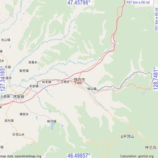
Tieli GPS coordinates[2]
46° 58' 49.548" North, 128° 2' 41.892" East
| Map corner | latitude | longitude |
|---|---|---|
| Upper-left | 47.45798°, | 127.34185° |
| Center: | 46.98043°, | 128.04497° |
| Lower-right: | 46.49857°, | 128.7481° |
| Map W x H: | 106.7×106.7 km | = 66.3×66.3mi |
| max Lat: | 53.31946° ⇑3.1% North |
| Tieli: | 46.98043° |
| min Lat: | ⇓96.9% South 18.22056° |
| min Long | Tieli | max Long |
| 75.07348° | 128.04497° | 134.28917° |
| W 98%⇐ | ⇒2% E |
Elevation
Elevation of Tieli is 214 m = 702 ft, and this is 270.8 m = 888 ft below average elevation for this country.
| Max E: |
5622 m = 18445 ft | 44.2% |
| Avg. | 484.8 m = 1591 ft | |
| Tieli | 214 m = 702 ft | |
Min E: |
-3 m = -10 ft | 55.8% |
See also: Tieli elevation on elevation.city.
Geographical zone
Tieli is located in North temperate zone (between Tropic of Cancer and the Arctic Circle). Distance of this North polar circle is 2177.4 km =1353 mi to North.| Distance of | km | miles | from Tieli |
|---|---|---|---|
| North Pole | 4783.3 | 2972.2 | to North |
| Arctic Circle | 2177.4 | 1353 | to North |
| Tropic Cancer | 2617.8 | 1626.6 | to South |
| Equator | 5223.7 | 3245.9 | to South |


Nearby cities:
15 places around Tieli: (largest is in red/bold)
• Fazhan
33.3 km =20.7 mi,  290°
290°
• Fengshou
37 km =23 mi,  251°
251°
• Gongnong
4.2 km =2.6 mi,  281°
281°
• Jianmin
44.1 km =27.4 mi,  237°
237°
• Liangli
25 km =15.5 mi, 238°
• Nianfeng
2.6 km =1.6 mi,  222°
222°
• Ping’an
31.1 km =19.3 mi,  261°
261°
• Qing’an
42.9 km =26.7 mi, 254°
• Qinlao
37.5 km =23.3 mi, 278°
• Shenshu
28.8 km =17.9 mi,  98°
98°
• Shuangfeng
22.3 km =13.9 mi,  266°
266°
• Taoshan
11.1 km =6.9 mi,  124°
124°
• Wangyang
9.5 km =5.9 mi, 261°
• Weiguo
20.2 km =12.6 mi, 241°
• Xinsheng
35.6 km =22.1 mi,  226°
226°
Sources, notices
• [Note1] Compared only with cities in China existing in our database
• [Src1] Map data: © OpenStreetMap contributors (CC-BY-SA)
• [Src2] Other city data from geonames.org with taken over terms of usage.
• [Src3] Geographical zone / Annual Mean Temperature by Robert A. Rohde @ Wikipedia
