Qikeshu geodata
Qikeshu (Heilongjiang) is a seat of a fourth-order administrative division; located in China in Asia/Shanghai (GMT+8) time zone. In our database, there are 1268 cities with bigger population. Compared to other cities in China, 98% of cities are located further ↓South; 93% of cities are located further ←West and 50.7% of cities have lower elevation than Qikeshu. Note1


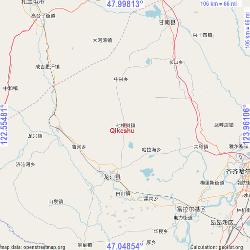
Qikeshu GPS coordinates[2]
47° 31' 31.728" North, 123° 15' 28.548" East
| Map corner | latitude | longitude |
|---|---|---|
| Upper-left | 47.99813°, | 122.55481° |
| Center: | 47.52548°, | 123.25793° |
| Lower-right: | 47.04854°, | 123.96106° |
| Map W x H: | 105.6×105.6 km | = 65.6×65.6mi |
| max Lat: | 53.31946° ⇑2% North |
| Qikeshu: | 47.52548° |
| min Lat: | ⇓98% South 18.22056° |
| min Long | Qikeshu | max Long |
| 75.07348° | 123.25793° | 134.28917° |
| W 93%⇐ | ⇒7% E |
Elevation
Elevation of Qikeshu is 171 m = 561 ft, and this is 313.8 m = 1030 ft below average elevation for this country.
| Max E: |
5622 m = 18445 ft | 49.3% |
| Avg. | 484.8 m = 1591 ft | |
| Qikeshu | 171 m = 561 ft | |
Min E: |
-3 m = -10 ft | 50.7% |
See also: China elevation on elevation.city.
Geographical zone
Qikeshu is located in North temperate zone (between Tropic of Cancer and the Arctic Circle). Distance of this North polar circle is 2116.8 km =1315.3 mi to North.| Distance of | km | miles | from Qikeshu |
|---|---|---|---|
| North Pole | 4722.7 | 2934.5 | to North |
| Arctic Circle | 2116.8 | 1315.3 | to North |
| Tropic Cancer | 2678.4 | 1664.3 | to South |
| Equator | 5284.3 | 3283.5 | to South |


Nearby cities:
15 places around Qikeshu: (largest is in red/bold)
• Baishan
28.7 km =17.8 mi,  182°
182°
• Changshan
34.3 km =21.3 mi,  38°
38°
• Dahewan
37.3 km =23.2 mi,  344°
344°
• Dahudian
41.5 km =25.8 mi,  89°
89°
• Duibao
31.2 km =19.4 mi,  208°
208°
• Gonghe
33.1 km =20.6 mi,  105°
105°
• Halahai
15.2 km =9.4 mi,  134°
134°
• Hali
37.1 km =23.1 mi, 126°
• Heigang
32.6 km =20.3 mi,  160°
160°
• Heshan
22.4 km =13.9 mi, 208°
• Longjiang
22.5 km =14 mi,  195°
195°
• Nianzishan
28.1 km =17.5 mi,  268°
268°
• Qinggis Han
40.4 km =25.1 mi,  308°
308°
• Ruiting
39.6 km =24.6 mi,  70°
70°
• Zhongxing
19.6 km =12.2 mi,  354°
354°
Sources, notices
• [Note1] Compared only with cities in China existing in our database
• [Src1] Map data: © OpenStreetMap contributors (CC-BY-SA)
• [Src2] Other city data from geonames.org with taken over terms of usage.
• [Src3] Geographical zone / Annual Mean Temperature by Robert A. Rohde @ Wikipedia
