Nianzishan geodata
Nianzishan (Heilongjiang) is a populated place; located in China in Asia/Shanghai (GMT+8) time zone. With population of 62,131 people, there are 694 cities with bigger population in this country. Compared to other cities in China, 97.9% of cities are located further ↓South; 92.6% of cities are located further ←West and 57.8% of cities have lower elevation than Nianzishan. Note1


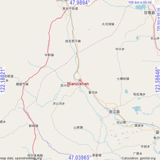
Nianzishan GPS coordinates[2]
47° 31' 0.012" North, 122° 52' 59.988" East
| Map corner | latitude | longitude |
|---|---|---|
| Upper-left | 47.9894°, | 122.18021° |
| Center: | 47.51667°, | 122.88333° |
| Lower-right: | 47.03965°, | 123.58646° |
| Map W x H: | 105.6×105.6 km | = 65.6×65.6mi |
| max Lat: | 53.31946° ⇑2.1% North |
| Nianzishan: | 47.51667° |
| min Lat: | ⇓97.9% South 18.22056° |
| min Long | Nianzishan | max Long |
| 75.07348° | 122.88333° | 134.28917° |
| W 92.6%⇐ | ⇒7.4% E |
Elevation
Elevation of Nianzishan is 234 m = 768 ft, and this is 250.8 m = 823 ft below average elevation for this country.
| Max E: |
5622 m = 18445 ft | 42.2% |
| Avg. | 484.8 m = 1591 ft | |
| Nianzishan | 234 m = 768 ft | |
Min E: |
-3 m = -10 ft | 57.8% |
See also: Nianzishan elevation on elevation.city.
Geographical zone
Nianzishan is located in North temperate zone (between Tropic of Cancer and the Arctic Circle). Distance of this North polar circle is 2117.8 km =1315.9 mi to North.| Distance of | km | miles | from Nianzishan |
|---|---|---|---|
| North Pole | 4723.7 | 2935.2 | to North |
| Arctic Circle | 2117.8 | 1315.9 | to North |
| Tropic Cancer | 2677.4 | 1663.7 | to South |
| Equator | 5283.4 | 3283 | to South |


Nearby cities:
15 places around Nianzishan: (largest is in red/bold)
• Baishan
38.7 km =24 mi,  135°
135°
• Dahewan
41.3 km =25.7 mi,  26°
26°
• Duibao
29.5 km =18.3 mi,  153°
153°
• Guanmenshan
43.8 km =27.2 mi,  251°
251°
• Halahai
40.1 km =24.9 mi,  104°
104°
• Heshan
25.7 km =16 mi, 136°
• Longjiang
30.3 km =18.8 mi,  132°
132°
• Moguqi
38.5 km =23.9 mi,  266°
266°
• Qikeshu
28.1 km =17.5 mi,  88°
88°
• Qinggis Han
26.2 km =16.3 mi,  351°
351°
• Xinlin
44.2 km =27.5 mi,  228°
228°
• Ya’ergenchu
32.8 km =20.4 mi,  321°
321°
• Yongfa
42 km =26.1 mi,  163°
163°
• Zhonghe
26.5 km =16.5 mi,  308°
308°
• Zhongxing
33.2 km =20.6 mi,  51°
51°
Sources, notices
• [Note1] Compared only with cities in China existing in our database
• [Src1] Map data: © OpenStreetMap contributors (CC-BY-SA)
• [Src2] Other city data from geonames.org with taken over terms of usage.
• [Src3] Geographical zone / Annual Mean Temperature by Robert A. Rohde @ Wikipedia
