Nanpiao geodata
Nanpiao (Liaoning) is a seat of a third-order administrative division; located in China in Asia/Shanghai (GMT+8) time zone. With population of 157,044 people, there are 277 cities with bigger population in this country. Compared to other cities in China, 89.4% of cities are located further ↓South; 86.5% of cities are located further ←West and 60.1% of cities have higher elevation than Nanpiao. Note1


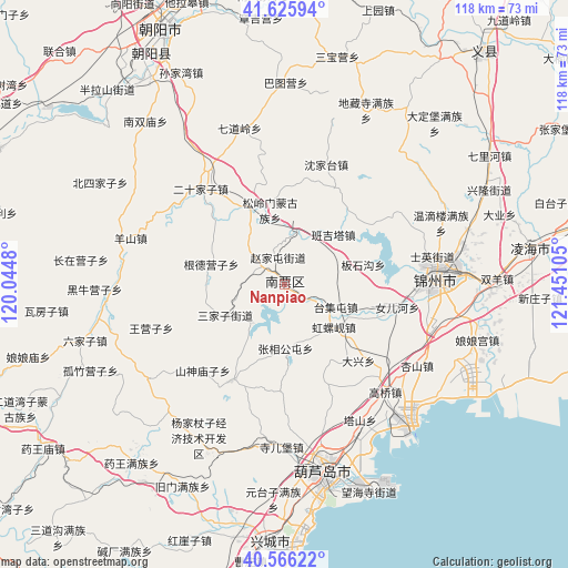
Nanpiao GPS coordinates[2]
41° 5' 53.592" North, 120° 44' 52.512" East
| Map corner | latitude | longitude |
|---|---|---|
| Upper-left | 41.62594°, | 120.0448° |
| Center: | 41.09822°, | 120.74792° |
| Lower-right: | 40.56622°, | 121.45105° |
| Map W x H: | 117.8×117.8 km | = 73.2×73.2mi |
| max Lat: | 53.31946° ⇑10.6% North |
| Nanpiao: | 41.09822° |
| min Lat: | ⇓89.4% South 18.22056° |
| min Long | Nanpiao | max Long |
| 75.07348° | 120.74792° | 134.28917° |
| W 86.5%⇐ | ⇒13.5% E |
Elevation
Elevation of Nanpiao is 98 m = 322 ft, and this is 386.8 m = 1269 ft below average elevation for this country.
| Max E: |
5622 m = 18445 ft | 60.1% |
| Avg. | 484.8 m = 1591 ft | |
| Nanpiao | 98 m = 322 ft | |
Min E: |
-3 m = -10 ft | 39.9% |
See also: Nanpiao elevation on elevation.city.
Geographical zone
Nanpiao is located in North temperate zone (between Tropic of Cancer and the Arctic Circle). Distance of this Northern Tropic circle is 1963.8 km =1220.2 mi to South.| Distance of | km | miles | from Nanpiao |
|---|---|---|---|
| North Pole | 5437.4 | 3378.6 | to North |
| Arctic Circle | 2831.5 | 1759.4 | to North |
| Tropic Cancer | 1963.8 | 1220.2 | to South |
| Equator | 4569.7 | 2839.5 | to South |


Nearby cities:
15 places around Nanpiao: (largest is in red/bold)
• Daxing
22 km =13.7 mi,  132°
132°
• Gangtun
22.7 km =14.1 mi,  208°
208°
• Gaoqiao
30.5 km =19 mi,  136°
136°
• Heiiyugou
36.5 km =22.7 mi, 206°
• Jinzhou
33 km =20.5 mi,  88°
88°
• Lianshan
38.2 km =23.7 mi,  166°
166°
• Maoqitun
36.7 km =22.8 mi, 207°
• Nuanchitang
10.5 km =6.5 mi,  222°
222°
• Shaguotun
6 km =3.7 mi,  307°
307°
• Shaheying
30.4 km =18.9 mi,  177°
177°
• Shanxi
24.8 km =15.4 mi, 223°
• Si’erbao
33.5 km =20.8 mi, 181°
• Taijitun
11.4 km =7.1 mi,  113°
113°
• Wanghu
17.8 km =11.1 mi, 113°
• Yingta
32.2 km =20 mi,  150°
150°
Sources, notices
• [Note1] Compared only with cities in China existing in our database
• [Src1] Map data: © OpenStreetMap contributors (CC-BY-SA)
• [Src2] Other city data from geonames.org with taken over terms of usage.
• [Src3] Geographical zone / Annual Mean Temperature by Robert A. Rohde @ Wikipedia
