Jinzhou geodata
Jinzhou (Liaoning) is a populated place; located in China in Asia/Shanghai (GMT+8) time zone. With population of 604,269 people, there are 108 cities with bigger population in this country. Compared to other cities in China, 89.4% of cities are located further ↓South; 88.4% of cities are located further ←West and 80.2% of cities have higher elevation than Jinzhou. Note1


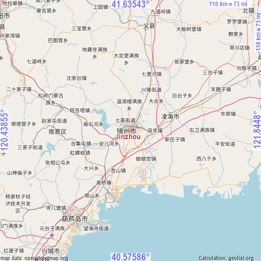
Jinzhou GPS coordinates[2]
41° 6' 28.008" North, 121° 8' 30.012" East
| Map corner | latitude | longitude |
|---|---|---|
| Upper-left | 41.63543°, | 120.43855° |
| Center: | 41.10778°, | 121.14167° |
| Lower-right: | 40.57586°, | 121.8448° |
| Map W x H: | 117.8×117.8 km | = 73.2×73.2mi |
| max Lat: | 53.31946° ⇑10.6% North |
| Jinzhou: | 41.10778° |
| min Lat: | ⇓89.4% South 18.22056° |
| min Long | Jinzhou | max Long |
| 75.07348° | 121.14167° | 134.28917° |
| W 88.4%⇐ | ⇒11.6% E |
Elevation
Elevation of Jinzhou is 26 m = 85 ft, and this is 458.8 m = 1505 ft below average elevation for this country.
| Max E: |
5622 m = 18445 ft | 80.2% |
| Avg. | 484.8 m = 1591 ft | |
| Jinzhou | 26 m = 85 ft | |
Min E: |
-3 m = -10 ft | 19.8% |
See also: Jinzhou elevation on elevation.city.
Geographical zone
Jinzhou is located in North temperate zone (between Tropic of Cancer and the Arctic Circle). Distance of this Northern Tropic circle is 1964.8 km =1220.9 mi to South.| Distance of | km | miles | from Jinzhou |
|---|---|---|---|
| North Pole | 5436.3 | 3378 | to North |
| Arctic Circle | 2830.4 | 1758.7 | to North |
| Tropic Cancer | 1964.8 | 1220.9 | to South |
| Equator | 4570.8 | 2840.2 | to South |


Nearby cities:
15 places around Jinzhou: (largest is in red/bold)
• Cishan
45.2 km =28.1 mi,  206°
206°
• Dabaimashi
43 km =26.7 mi, 207°
• Daxing
23 km =14.3 mi,  226°
226°
• Gaoqiao
26.2 km =16.3 mi, 207°
• Lianshan
45.2 km =28.1 mi, 212°
• Linghai
19.9 km =12.4 mi,  71°
71°
• Longgang
46.6 km =29 mi,  202°
202°
• Nanpiao
33 km =20.5 mi,  268°
268°
• Nuanchitang
41 km =25.5 mi,  257°
257°
• Shaguotun
37.8 km =23.5 mi, 273°
• Shaheying
44.7 km =27.8 mi, 225°
• Taijitun
23.3 km =14.5 mi, 256°
• Wanghu
18.5 km =11.5 mi,  244°
244°
• Yingta
33.9 km =21.1 mi, 210°
• Yuhuang
47 km =29.2 mi, 207°
Sources, notices
• [Note1] Compared only with cities in China existing in our database
• [Src1] Map data: © OpenStreetMap contributors (CC-BY-SA)
• [Src2] Other city data from geonames.org with taken over terms of usage.
• [Src3] Geographical zone / Annual Mean Temperature by Robert A. Rohde @ Wikipedia
