Lanxi geodata
Lanxi (Heilongjiang) is a seat of a third-order administrative division; located in China in Asia/Shanghai (GMT+8) time zone. With population of 72,528 people, there are 591 cities with bigger population in this country. Compared to other cities in China, 95.5% of cities are located further ↓South; 95.9% of cities are located further ←West and 50% of cities have lower elevation than Lanxi. Note1


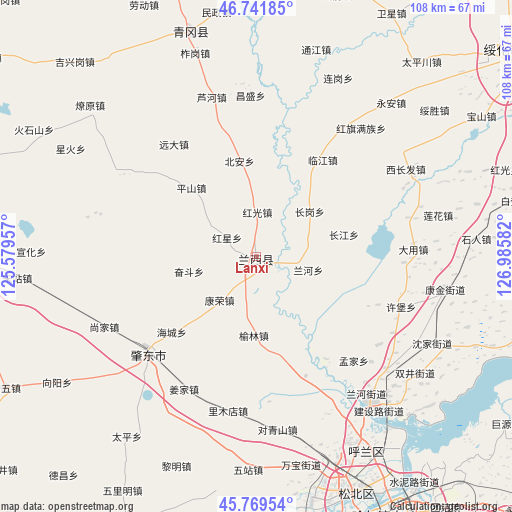
Lanxi GPS coordinates[2]
46° 15' 28.26" North, 126° 16' 57.684" East
| Map corner | latitude | longitude |
|---|---|---|
| Upper-left | 46.74185°, | 125.57957° |
| Center: | 46.25785°, | 126.28269° |
| Lower-right: | 45.76954°, | 126.98582° |
| Map W x H: | 108.1×108.1 km | = 67.2×67.2mi |
| max Lat: | 53.31946° ⇑4.5% North |
| Lanxi: | 46.25785° |
| min Lat: | ⇓95.5% South 18.22056° |
| min Long | Lanxi | max Long |
| 75.07348° | 126.28269° | 134.28917° |
| W 95.9%⇐ | ⇒4.1% E |
Elevation
Elevation of Lanxi is 164 m = 538 ft, and this is 320.8 m = 1052 ft below average elevation for this country.
| Max E: |
5622 m = 18445 ft | 50% |
| Avg. | 484.8 m = 1591 ft | |
| Lanxi | 164 m = 538 ft | |
Min E: |
-3 m = -10 ft | 50% |
See also: Lanxi elevation on elevation.city.
Geographical zone
Lanxi is located in North temperate zone (between Tropic of Cancer and the Arctic Circle). Distance of this North polar circle is 2257.8 km =1402.9 mi to North.| Distance of | km | miles | from Lanxi |
|---|---|---|---|
| North Pole | 4863.7 | 3022.2 | to North |
| Arctic Circle | 2257.8 | 1402.9 | to North |
| Tropic Cancer | 2537.5 | 1576.7 | to South |
| Equator | 5143.4 | 3196 | to South |


Nearby cities:
15 places around Lanxi: (largest is in red/bold)
• Bei’an
20.7 km =12.9 mi,  350°
350°
• Changgang
15.1 km =9.4 mi,  49°
49°
• Changjiang
19 km =11.8 mi,  75°
75°
• Dayong
33.4 km =20.8 mi, 84°
• Hongguang
9.5 km =5.9 mi,  1°
1°
• Hongxing
7.3 km =4.5 mi,  303°
303°
• Kangrong
7.5 km =4.7 mi,  199°
199°
• Lanhe
13.3 km =8.3 mi,  112°
112°
• Linjiang
24.8 km =15.4 mi,  34°
34°
• Mengjia
30.3 km =18.8 mi,  136°
136°
• Pingshan
20.1 km =12.5 mi,  316°
316°
• Xubao
32.3 km =20.1 mi, 109°
• Yuanda
29.6 km =18.4 mi, 323°
• Yulin
16.4 km =10.2 mi,  181°
181°
• Zhaodong
31.3 km =19.4 mi,  227°
227°
Sources, notices
• [Note1] Compared only with cities in China existing in our database
• [Src1] Map data: © OpenStreetMap contributors (CC-BY-SA)
• [Src2] Other city data from geonames.org with taken over terms of usage.
• [Src3] Geographical zone / Annual Mean Temperature by Robert A. Rohde @ Wikipedia
