Yuanda geodata
Yuanda (Heilongjiang) is a seat of a fourth-order administrative division; located in China in Asia/Shanghai (GMT+8) time zone. In our database, there are 1268 cities with bigger population. Compared to other cities in China, 95.9% of cities are located further ↓South; 95.6% of cities are located further ←West and 52.7% of cities have lower elevation than Yuanda. Note1


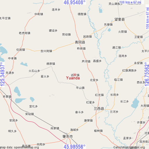
Yuanda GPS coordinates[2]
46° 28' 19.128" North, 126° 3' 8.964" East
| Map corner | latitude | longitude |
|---|---|---|
| Upper-left | 46.95408°, | 125.34937° |
| Center: | 46.47198°, | 126.05249° |
| Lower-right: | 45.98558°, | 126.75562° |
| Map W x H: | 107.7×107.7 km | = 66.9×66.9mi |
| max Lat: | 53.31946° ⇑4.1% North |
| Yuanda: | 46.47198° |
| min Lat: | ⇓95.9% South 18.22056° |
| min Long | Yuanda | max Long |
| 75.07348° | 126.05249° | 134.28917° |
| W 95.6%⇐ | ⇒4.4% E |
Elevation
Elevation of Yuanda is 186 m = 610 ft, and this is 298.8 m = 980 ft below average elevation for this country.
| Max E: |
5622 m = 18445 ft | 47.3% |
| Avg. | 484.8 m = 1591 ft | |
| Yuanda | 186 m = 610 ft | |
Min E: |
-3 m = -10 ft | 52.7% |
See also: China elevation on elevation.city.
Geographical zone
Yuanda is located in North temperate zone (between Tropic of Cancer and the Arctic Circle). Distance of this North polar circle is 2234 km =1388.1 mi to North.| Distance of | km | miles | from Yuanda |
|---|---|---|---|
| North Pole | 4839.9 | 3007.4 | to North |
| Arctic Circle | 2234 | 1388.1 | to North |
| Tropic Cancer | 2561.3 | 1591.5 | to South |
| Equator | 5167.2 | 3210.7 | to South |


Nearby cities:
15 places around Yuanda: (largest is in red/bold)
• Bei’an
14.8 km =9.2 mi,  103°
103°
• Changsheng
19.4 km =12.1 mi,  57°
57°
• Hongguang
23 km =14.3 mi,  128°
128°
• Hongxing
22.9 km =14.2 mi,  149°
149°
• Huoshishan
29.1 km =18.1 mi,  276°
276°
• Jixinggang
26.7 km =16.6 mi,  310°
310°
• Lanxi
29.6 km =18.4 mi,  143°
143°
• Liaoyuan
19 km =11.8 mi,  295°
295°
• Linjiang
31.9 km =19.8 mi, 96°
• Luhe
12.9 km =8 mi,  39°
39°
• Minzheng
29.2 km =18.1 mi,  18°
18°
• Pingshan
10 km =6.2 mi,  156°
156°
• Qinggang
24 km =14.9 mi,  9°
9°
• Xinghuo
21.5 km =13.4 mi,  267°
267°
• Zhagang
19.8 km =12.3 mi, 14°
Sources, notices
• [Note1] Compared only with cities in China existing in our database
• [Src1] Map data: © OpenStreetMap contributors (CC-BY-SA)
• [Src2] Other city data from geonames.org with taken over terms of usage.
• [Src3] Geographical zone / Annual Mean Temperature by Robert A. Rohde @ Wikipedia
