E’erguna geodata
E’erguna (Inner Mongolia) is a seat of a third-order administrative division; located in China in Asia/Shanghai (GMT+8) time zone. In our database, there are 1268 cities with bigger population. Compared to other cities in China, 99.6% of cities are located further ↓South; 83% of cities are located further ←West and 77% of cities have lower elevation than E’erguna. Note1


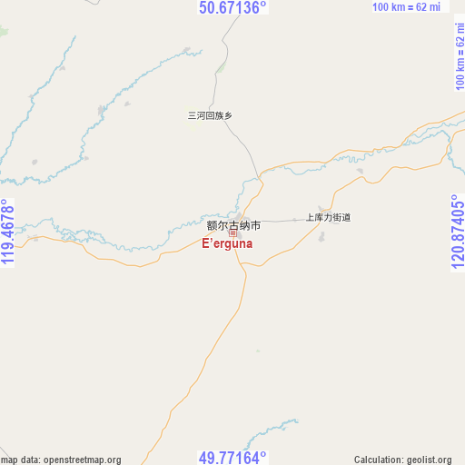
E’erguna GPS coordinates[2]
50° 13' 25.032" North, 120° 10' 15.312" East
| Map corner | latitude | longitude |
|---|---|---|
| Upper-left | 50.67136°, | 119.4678° |
| Center: | 50.22362°, | 120.17092° |
| Lower-right: | 49.77164°, | 120.87405° |
| Map W x H: | 100×100 km | = 62.1×62.1mi |
| max Lat: | 53.31946° ⇑0.4% North |
| E’erguna: | 50.22362° |
| min Lat: | ⇓99.6% South 18.22056° |
| min Long | E’erguna | max Long |
| 75.07348° | 120.17092° | 134.28917° |
| W 83%⇐ | ⇒17% E |
Elevation
Elevation of E’erguna is 576 m = 1890 ft, and this is 91.2 m = 299 ft above average elevation for this country.
| Max E: |
5622 m = 18445 ft | 23% |
| E’erguna | 576 m 1890 ft | |
| Avg. | 484.8 m = 1591 ft | |
Min E: |
-3 m = -10 ft | 77% |
See also: China elevation on elevation.city.
Geographical zone
E’erguna is located in North temperate zone (between Tropic of Cancer and the Arctic Circle). Distance of this North polar circle is 1816.8 km =1128.9 mi to North.| Distance of | km | miles | from E’erguna |
|---|---|---|---|
| North Pole | 4422.7 | 2748.1 | to North |
| Arctic Circle | 1816.8 | 1128.9 | to North |
| Tropic Cancer | 2978.4 | 1850.7 | to South |
| Equator | 5584.3 | 3469.9 | to South |


Nearby cities:
15 places around E’erguna: (largest is in red/bold)
• Baorixile
101.4 km =63 mi,  195°
195°
• Bayan Hure
93.1 km =57.8 mi,  210°
210°
• Derbur
105.9 km =65.8 mi,  36°
36°
• Haolibao
108.1 km =67.2 mi,  58°
58°
• Heishantou
47.4 km =29.5 mi,  268°
268°
• Kudu’er
105.1 km =65.3 mi,  101°
101°
• Sanhe
25.5 km =15.8 mi,  349°
349°
• Shangkuli
21 km =13 mi,  79°
79°
• Suqin Huimin
38.3 km =23.8 mi,  312°
312°
• Tulihe
110.5 km =68.7 mi,  74°
74°
• Xie’ertala
104.3 km =64.8 mi,  190°
190°
• Xingong
110.7 km =68.8 mi,  159°
159°
• Xiniqi
109.9 km =68.3 mi, 80°
• Yitulihe
109 km =67.7 mi, 65°
• Yuanlin
94.6 km =58.8 mi,  113°
113°
Sources, notices
• [Note1] Compared only with cities in China existing in our database
• [Src1] Map data: © OpenStreetMap contributors (CC-BY-SA)
• [Src2] Other city data from geonames.org with taken over terms of usage.
• [Src3] Geographical zone / Annual Mean Temperature by Robert A. Rohde @ Wikipedia
