Heishantou geodata
Heishantou (Inner Mongolia) is a seat of a fourth-order administrative division; located in China in Asia/Shanghai (GMT+8) time zone. In our database, there are 1268 cities with bigger population. Compared to other cities in China, 99.6% of cities are located further ↓South; 78.8% of cities are located further ←West and 75.9% of cities have lower elevation than Heishantou. Note1


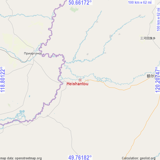
Heishantou GPS coordinates[2]
50° 12' 50.004" North, 119° 30' 15.624" East
| Map corner | latitude | longitude |
|---|---|---|
| Upper-left | 50.66172°, | 118.80122° |
| Center: | 50.21389°, | 119.50434° |
| Lower-right: | 49.76182°, | 120.20747° |
| Map W x H: | 100.1×100.1 km | = 62.2×62.2mi |
| max Lat: | 53.31946° ⇑0.4% North |
| Heishantou: | 50.21389° |
| min Lat: | ⇓99.6% South 18.22056° |
| min Long | Heishantou | max Long |
| 75.07348° | 119.50434° | 134.28917° |
| W 78.8%⇐ | ⇒21.2% E |
Elevation
Elevation of Heishantou is 544 m = 1785 ft, and this is 59.2 m = 194 ft above average elevation for this country.
| Max E: |
5622 m = 18445 ft | 24.1% |
| Heishantou | 544 m 1785 ft | |
| Avg. | 484.8 m = 1591 ft | |
Min E: |
-3 m = -10 ft | 75.9% |
See also: China elevation on elevation.city.
Geographical zone
Heishantou is located in North temperate zone (between Tropic of Cancer and the Arctic Circle). Distance of this North polar circle is 1817.9 km =1129.6 mi to North.| Distance of | km | miles | from Heishantou |
|---|---|---|---|
| North Pole | 4423.8 | 2748.8 | to North |
| Arctic Circle | 1817.9 | 1129.6 | to North |
| Tropic Cancer | 2977.3 | 1850 | to South |
| Equator | 5583.3 | 3469.3 | to South |


Nearby cities:
15 places around Heishantou: (largest is in red/bold)
• Baorixile
98.5 km =61.2 mi,  168°
168°
• Bayan Hure
79.4 km =49.3 mi,  179°
179°
• Bayan Tuohai
121.3 km =75.4 mi, 172°
• Bayin Tala Dahan’er Minzu
134.1 km =83.3 mi, 173°
• E’erguna
47.4 km =29.5 mi,  88°
88°
• Fendou
114.6 km =71.2 mi, 170°
• Hailar
113.6 km =70.6 mi, 172°
• Hake
121.2 km =75.3 mi,  160°
160°
• Jianshe
108.3 km =67.3 mi, 169°
• Sanhe
50 km =31.1 mi,  58°
58°
• Shangkuli
68.3 km =42.4 mi, 86°
• Shiwei
127.5 km =79.2 mi,  12°
12°
• Suqin Huimin
33 km =20.5 mi,  35°
35°
• Wangong
122.2 km =75.9 mi,  201°
201°
• Xie’ertala
105.5 km =65.6 mi, 164°
Sources, notices
• [Note1] Compared only with cities in China existing in our database
• [Src1] Map data: © OpenStreetMap contributors (CC-BY-SA)
• [Src2] Other city data from geonames.org with taken over terms of usage.
• [Src3] Geographical zone / Annual Mean Temperature by Robert A. Rohde @ Wikipedia
