Taikang geodata
Taikang (Heilongjiang) is a seat of a third-order administrative division; located in China in Asia/Shanghai (GMT+8) time zone. With population of 55,316 people, there are 788 cities with bigger population in this country. Compared to other cities in China, 96.7% of cities are located further ↓South; 94.3% of cities are located further ←West and 52.6% of cities have higher elevation than Taikang. Note1


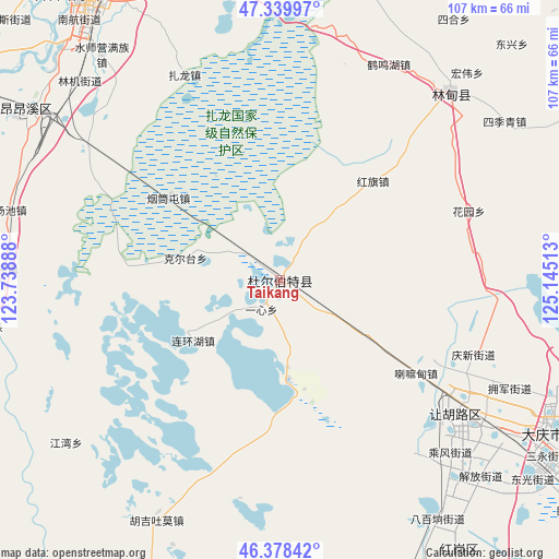
Taikang GPS coordinates[2]
46° 51' 40.86" North, 124° 26' 31.2" East
| Map corner | latitude | longitude |
|---|---|---|
| Upper-left | 47.33997°, | 123.73888° |
| Center: | 46.86135°, | 124.442° |
| Lower-right: | 46.37842°, | 125.14513° |
| Map W x H: | 106.9×106.9 km | = 66.4×66.4mi |
| max Lat: | 53.31946° ⇑3.3% North |
| Taikang: | 46.86135° |
| min Lat: | ⇓96.7% South 18.22056° |
| min Long | Taikang | max Long |
| 75.07348° | 124.442° | 134.28917° |
| W 94.3%⇐ | ⇒5.7% E |
Elevation
Elevation of Taikang is 146 m = 479 ft, and this is 338.8 m = 1112 ft below average elevation for this country.
| Max E: |
5622 m = 18445 ft | 52.6% |
| Avg. | 484.8 m = 1591 ft | |
| Taikang | 146 m = 479 ft | |
Min E: |
-3 m = -10 ft | 47.4% |
See also: Taikang elevation on elevation.city.
Geographical zone
Taikang is located in North temperate zone (between Tropic of Cancer and the Arctic Circle). Distance of this North polar circle is 2190.7 km =1361.2 mi to North.| Distance of | km | miles | from Taikang |
|---|---|---|---|
| North Pole | 4796.6 | 2980.5 | to North |
| Arctic Circle | 2190.7 | 1361.2 | to North |
| Tropic Cancer | 2604.6 | 1618.4 | to South |
| Equator | 5210.5 | 3237.7 | to South |


Nearby cities:
15 places around Taikang: (largest is in red/bold)
• Baiyinnuole
20.2 km =12.6 mi,  235°
235°
• Daqing
52.6 km =32.7 mi,  126°
126°
• Fendou
40.3 km =25 mi, 127°
• Hongqi
25.8 km =16 mi,  42°
42°
• Huayuan
37.8 km =23.5 mi,  70°
70°
• Hujil Tohom
51.7 km =32.1 mi,  207°
207°
• Jiangwan
51.5 km =32 mi,  232°
232°
• Kertai
18.6 km =11.6 mi,  282°
282°
• Lamadian
31.7 km =19.7 mi, 125°
• Liming
52.4 km =32.6 mi,  54°
54°
• Lindian
48.1 km =29.9 mi, 42°
• Sanhe
45.9 km =28.5 mi,  26°
26°
• Yantongtun
26.5 km =16.5 mi,  308°
308°
• Yixin
6.8 km =4.2 mi, 213°
• Zhalong
43 km =26.7 mi,  334°
334°
Sources, notices
• [Note1] Compared only with cities in China existing in our database
• [Src1] Map data: © OpenStreetMap contributors (CC-BY-SA)
• [Src2] Other city data from geonames.org with taken over terms of usage.
• [Src3] Geographical zone / Annual Mean Temperature by Robert A. Rohde @ Wikipedia
